Sep 4, 2019 | Austria, Environment, Risk and resilience, Women in Science
By Marlene Palka, research assistant in the IIASA Risk and Resilience Program
Marlene Palka discusses the work done by the IIASA FARM project, which has been investigating drought risk management in Austria for the past three years.
Future climate projections forecast an increase in both the frequency and severity of droughts, with the agricultural sector in particular being vulnerable to such extreme weather events. In contrast to most other climatic extremes, droughts can hit larger regions and often for extended periods – up to several months or even years. Like many other countries, Austria has been and is expected to be increasingly affected, making it necessary to devise a management strategy to mitigate drought damages and tackle related problems. The FARM project – a three year project financed by the Austrian Climate Research Program and run by the IIASA Risk and Resilience and Ecosystems Services and Management programs – kicked off in 2017 and has been investigating agricultural drought risk management both in a broad European context, and more specifically in Austria.
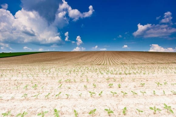
Young sunflowers on dry field © Werner Münzker | Dreamstime.com
Austria represents a good case study for agricultural drought risk management. Despite the agricultural sector’s rather small contribution to the country’s economic performance, it still has value and represents an important part of the country’s historical and cultural tradition. Around 80% of Austria’s total land area is used for agricultural and forestry activities. Equally important is its contribution to the preservation of landscapes, which is invaluable for many other sectors including tourism.
Globally, agricultural insurance is a widely used risk management instrument that is often heavily subsidized. Apart from the fact that the concept is increasingly being supported by European policymakers – the intention being that insurance should play a more prominent role in managing agricultural production risk – more and more voices from other sectors are calling for holistic management approaches in agriculture with the overall aim of increasing the resilience of the system.
There is a well-established mutual agricultural insurance company in Austria, which has high insurance penetration rates of up to 75% for arable land, and comparably high subsidies of up to 55% of insurance premiums. It is also encouraging to note that recent policy decisions support the timeliness of drought risk: in 2013, the Austrian government paid EUR 36 million in drought compensation to grassland farmers and in 2016, premium subsidies of 50% were expanded to other insurance products, including drought, while ad-hoc compensation due to drought was officially eliminated. In 2018, the subsidy rate was further increased to 55%. In light of these prospects, we investigated the management option space of the Austrian agricultural sector as part of the FARM project.
The 2018 Organisation for Economic Co-operation and Development (OECD) report on monitoring and evaluation of agricultural policies claims that efficient (drought) risk management in agriculture must consider the interactions and trade-offs between different on-farm measures, activities of the private sector, and government policies. The report further argues that holistic approaches on all management levels will be vital to the success of any agricultural management strategy.
In the course of our work, we found that agricultural drought risk management in Austria lacks decision making across levels. Although there is a range of drought management measures available at different levels, cooperation that includes farms, public and private businesses, and policy institutions is often missing. In addition, measures to primarily and exclusively deal with drought, such as insurance and irrigation, are not only limited, but (as we found) are also less frequently implemented.
As far as insurance is concerned, products are still being developed, and penetration rates are currently low. Drought risk is also highly uncertain, making it almost impossible to offer extensive drought insurance products. Irrigation is perceived as the most obvious drought management measure among non-agronomists. Simply increasing irrigation to deal with the consequences of drought could however lead to increased water demand at times when water is already in short supply, while also incurring tremendous financial and labor costs and additional stress to farmers. With that said, a large number of agricultural practices may also holistically prevent, cope with, or mitigate droughts. For example, reduced soil management practices are low in operating costs and prevent surface run-off, while simultaneously maintaining a soil structure that facilitates increased water holding capacity. Market futures might also stabilize farm income and therefore allow for future planning such as the purchase of irrigation equipment.
A workshop we held with experts from the Austrian agricultural sector further highlighted this gap. Thinking (not even yet acting) beyond the personal field of action was rare. The results of a survey we conducted showed that farmers were experiencing feelings of helplessness regarding their ability to manage the negative effects of droughts and other climatic extremes despite the implementation of a broad range of management solutions. One way to explain this could be a lack of cooperation across different management levels, meaning that existing efforts – although elaborate and well-proven – potentially reach their limit of effectiveness sooner rather than later.
Due to the more complex effects of any indirect/holistic drought management measure, we need tailored policies that take potential interdependencies and trade-offs into account. With evidence from the FARM project, my colleagues and I would like to emphasize an integrated risk management approach, not only at farm level but also in all relevant agencies of the agricultural sector in an economy. This will help to secure future production and minimize the need for additional public financial resources. Our findings not only contribute to ongoing high-level discussions, but also underpin the resulting claim for more holistic (drought) risk management with bottom-up data from our stakeholder work.
Note: This article gives the views of the author, and not the position of the Nexus blog, nor of the International Institute for Applied Systems Analysis.
Nov 2, 2018 | Citizen Science, Ecosystems, Environment, Food
by Rastislav Skalsky, Ecosystems Services and Management Program, International Institute for Applied Systems Analysis
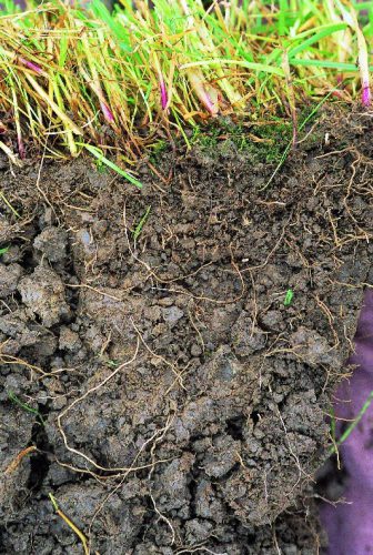
Clay soil
As growers, we know soil is important. It supports plants, and provides nutrients and water for them to grow. But do we all appreciate how crucial the role of soil is in continuously supplying plants with water, even when it hasn’t rained for a few days or even weeks, even without extra water being added via watering?
Soil is like a sponge. It can retain rain water and, if it is not taken up by plants, soil can store it for a long time. We can feel the water in soil as soil moisture. Try it — take and hold a lump (clod) of soil — if it is wet it will leave a spot on your palm. If it’s only moist then it will feel cold — cooler than the air around. And if the soil is dry, it will feel a little warm.
Soil moisture not only can be felt, but it can also be measured — in the lab, or directly in the field with professional or low-cost soil moisture sensors.
Soil moisture in general indicates how much water is contained by the soil. But it is not always the case that soil which feels moist or wet is able to support plants. It could happen that, despite feeling moist, the soil simply does not hold enough water, or holds the water too tightly for the plants to extract it. Or the opposite, soil can sometimes contain too much water. To understand how this works, one has to learn more about how water is stored in the soil.
Water is bound to soil by physical forces. Some forces are too weak to hold water in the plant root zone and water percolates to deeper layers, where plants can no longer reach it. Other forces can be too strong, preventing water from being retrieved by the roots.
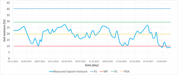
Figure 1
If soil moisture is measured at one place over time, it can reveal its seasonal dynamics. Having estimated important soil water content thresholds (FS — full saturation, FC — field capacity, PDA — point of decreased availability, and WP — wilting point) for that particular site, e.g. based on soil texture test or measurement, one can easily interpret if the measured soil moisture and say if there was enough water or not to fully support plants with water and air. In this particular case of sandy 0–30 cm deep topsoil from Slovakia, it was never wet enough to cause oxygen stress for plants, — in fact it never reached state of all capillary voids filled with water (FC). On the other hand, each summer the topsoil moisture dropped below the point of decreased availability (PDA), even got close to the wilting point or went through (WP), which means that during those periods plants suffered drought conditions.
Thresholds
In order to describe this behavior in more useful terms, plant ecologists and soil hydrologists came up with couple of important soil water content thresholds (Figure 1). These thresholds, also called “soil moisture ecological intervals”, define how easily plants can get the water out of the soil.
We speak about full saturation of soil when all empty spaces (pores/voids) are completely filled with water. Full saturation of the soil with water prevents air entering into the soil. Yet there is no force holding water in the soil. Roots need air as well as water so, if this situation continues, it eventually causes oxygen stress for most of the common plants because roots simply cannot breathe.
Soil also has different types of pores. Larger ones, which are called “gravitational pores”, are filled with water only when the soil is saturated and otherwise drains freely, and smaller ones called “capillary pores” which are small enough in size to prevent water from percolating down the soil profile by gravitation. These smaller pores can hold water even in well-drained soils and make it available for plants to extract. There are also even smaller pores where the water is held so tightly that plants cannot extract it.
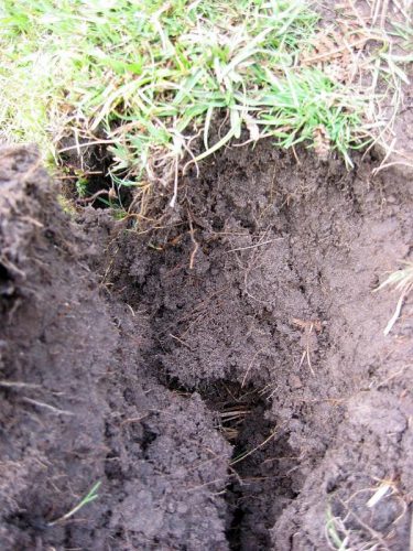
Sandy soil
When all gravitational pores/voids are empty of water and it is present only in so called capillary pores/void we speak about the field water capacity — which is considered to be the best soil moisture status of the soil — enabling plants to retrieve the water they need, whilst leaving enough air for roots to breathe. If no new water is added into the soil, the soil dries as water is used by plants or evaporates. As soil dries less water is available to plants until the point of decreased availability when water remains only in the smallest capillary pores/voids. But this water is bound to soil particles so strongly that most plants are not able to extract it suffer from drought. Ultimately, all the available water is used up by plants, and the remaining water is inaccessible. Soil reaches the so-called wilting point and water is not available for the plants anymore. Plants permanently wilt and eventually die.
How Soil Characteristics Relate to Moisture
The tricky thing with soil moisture however is that the same amount of water (volumetric percent of the total soil column volume) can, in different soils, represent different amount of water available for plants. How big this difference could be is defined by many soil characteristics.
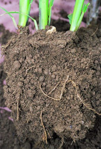
Loamy soil
The most important is the soil texture — a blend of all fine-earth soil mineral constituents (sand, silt, clay) and stones in various rates. In general, the finer the texture is (i.e. more clay, less sand) the more water is bound in the soil too tightly to be retrieved by plants. Even if the soil feels moist, plants can permanently wilt in clay soils. In contrast, those soils with coarse texture (i.e. more sand, less clay) can support plants with nearly all the water they can hold. Although the soil looks dry, plants can still effectively take the water out of it. The drawback here is that in coarse textured, sandy, soil nearly all water drains down the gravitational pores and therefore such a soil cannot support plants for very long time. That is also why medium textured soils (loam, silty loam, clay loam) are considered best for holding and providing the water for plants. Medium textured soils can effectively drain excess water, yet hold much water in capillary pores/voids for a long time, and still, only a relatively small amount of water remains unavailable for the plants.
A practical implication of this behavior of soil with different soil texture could be that one has to apply slightly different strategies to maintain soil moisture in the way that it can effectively supply plants with water. Sandy soils will require more frequent watering with smaller amount of water. It would not make any practical sense to try build-up a storage of water in these soils. All extra water added will simply drain out of the topsoil. Clay rich soils can absorb big amounts of water but a lot is bounded too strongly to the soil particles and thus not available for the plants. Therefore one should water even if the soil looks moist or wet — and if dry a lot of water must be added to recharge the topsoil so that it can support plants effectively. With loamy soils it is possible to be more relaxed with watering frequency, simply because one can build solid storage of water in such soils. Adding a bit more water than is necessary is perfectly fine with these soils because the water is effectively kept in the soil profile and it can be used later on.
Interested in learning more? Why not sign up for GROW Observatory’s next free online course – Citizen Research: From Data to Action – to discover how citizen-generated data on soils, food and a changing climate can create positive change in the world. Starts 5th November.
This blog was originally published on https://medium.com/grow-observatory-blog/moisture-matters-a9e33dc880a1
Oct 5, 2018 | Climate, Climate Change, Ecosystems, Environment, Food, Food & Water, History, Young Scientists
© Marcus Thomson
By Marcus Thomson, researcher, IIASA Ecosystems Services and Management Program
While living in Cairo in 2010, I witnessed first-hand the human toll of political and environmental disasters that washed over Africa at the end of the last century. Unprecedented numbers of migrants were pressing into North Africa, many pushed out of their homelands by conflict and state-failure, pulled towards safer, richer, less fragile places like Europe. Throughout Sub-Saharan Africa, climate change was driving up competition for scarce land and water, and raising pressure on farmers to maintain the quantity and quality of their crops.
It is a similar story throughout the developing world, where many farmers do without the use of expensive chemical fertilizer and pesticides, complex irrigation, or boutique seed varieties. They rely instead on traditional land management practices that developed over long periods with consistent, predictable conditions. It is difficult to predict how dryland farmers will respond to climate change; so it is challenging to plan for various social, economic, and political problems expected to develop under, or be exacerbated by, climate change. Will it spur innovation or, as has been argued for the Syrian civil war[1], set up conflict? A major stumbling block is that the dynamics of human social behavior are so difficult to model.
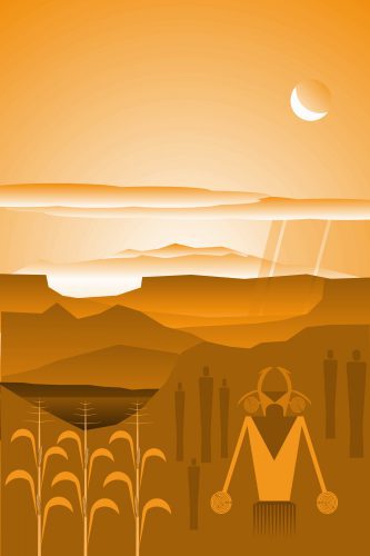
Instead of attempting to predict farmers’ responses to climate change by modelling human behavior, we can look to the responses to environmental changes of farmers from the past as analogues for many subsistence farmers of the future. Methods to fill in historical gaps, and reconstruct the prehistoric record, are valuable because they expand the set of observed cases of societal-scale responses to environmental change. For instance, some 2000 years ago, an expansive maize-growing cultural complex, the Ancestral Puebloans (APs), was well established in the arid American Southwest. By AD 1000, members of this AP complex produced unique and innovative material culture including the famed “Great Houses”, the largest built structures in the United States until the 19th century. However, between AD 1150 and 1350, there was a profound demographic transformation throughout the Southwest linked to climate change. We now know that many APs migrated elsewhere. As a PhD student at the University of California, Los Angeles, I wondered whether a shift to cooler, more variable conditions of the “Little Ice Age” (LIA, roughly AD 1300 to 1850) was linked to the production of their staple crop, maize.
I came to IIASA as a YSSP in 2016 to collaborate with crop modelers on this question, and our work has just been published in the journal Quaternary International.[2] I brought with me high-resolution data from a state-of-the-art climate model to drive the crop simulations, and AP site information collected by archaeologists. Because AP maize was quite different from modern corn, I worked with IIASA soil scientist Juraj Balkovič to modify the crop simulator with parameters derived from heirloom varieties still grown by indigenous peoples in the Southwest. I and IIASA economic geographer Tamás Krisztin developed a statistical technique to analyze the dynamical relationship between AP site occupation and simulated yield outcomes.
We found that for the most climate-stressed high-elevation sites, abandonments were most associated with increased year-to-year yield variability; and for the least stressed low-elevation and well-watered sites, abandonment was more likely due to endogenous stressors, such as soil degradation and population pressure. Crucially, we found that across all regions, populations peaked during periods of the most stable year-to-year crop yields, even though these were also relatively warm and dry periods. In short, we found that AP maize farmers adapted well to gradually rising temperatures and drought, during the MCA, but failed to adapt to increased climate variability after ~AD 1150, during the LIA. Because increased variability is one of the near certainties for dryland farming zones under global warming, the AP experience offers a cautionary example of the limits of low-technology adaptation to climate change, a business-as-usual direction for many sub-Saharan dryland farmers.
This is a lesson from the past that policymakers might take note of.
[1] Kelley, C. P., Mohtadi, S., Cane, M. A., Seager, R., & Kushnir, Y. (2015). Climate change in the Fertile Crescent and implications of the recent Syrian drought. Proceedings of the National Academy of Sciences, 201421533.
[2] Thomson, M. J., Balkovič, J., Krisztin, T., MacDonald, G. M. (2018). Simulated crop yield for Zea mays for Fremont Ancestral Puebloan sites in Utah between 850-1499 CE based on temperature dailies from a statistically downscaled climate model. Quaternary International. https://doi.org/10.1016/j.quaint.2018.09.031
May 30, 2018 | Economics, Food & Water, Sustainable Development, Systems Analysis
By Alan Nicol, Strategic Program Leader at the International Water Management Institute (IWMI)
I was at the local corner store in Uganda last week and noticed the profusion of rice being sold, the origin of which was from either India or Pakistan. It is highly likely that this rice being consumed in Eastern Africa, was produced in the Indus Basin, using Indus waters, and was then processed and shipped to Africa. That is not exceptional in its own right and is, arguably, a sign of a healthy global trading system.
Nevertheless, the rice in question is likely from a system under increasing stress, one that is often simply viewed as a hydrological (i.e., basin) unit. What my trip to the corner store shows is that perhaps more than ever before a system such as the Indus is no longer confined–it extends well beyond its physical (hydrological) borders.
Not only does this rice represent embedded ‘virtual’ water (the water used to grow and refine the produce), but it also represents policy decisions, embedded labor value, and the gamut of economic agreements between distribution companies and import entities, as well as the political relationship between East Africa and South Asia. On top of that are the global prices for commodities and international market forces.
In that sense, the Indus River Basin is the epitome of a complex system in which simple, linear causality may not be a useful way for decision makers to determine what to do and how to invest in managing the system into the future. Integral to this biophysical system, are social, economic, and political systems in which elements of climate, population growth and movement, and political uncertainty make decisions hard to get right.
Like other systems, it is constantly changing and endlessly complex, representing a great deal of interconnectivity. This poses questions about stability, sustainability, and hard choices and trade-offs that need to be made, not least in terms of the social and economic cost-benefit of huge rice production and export.
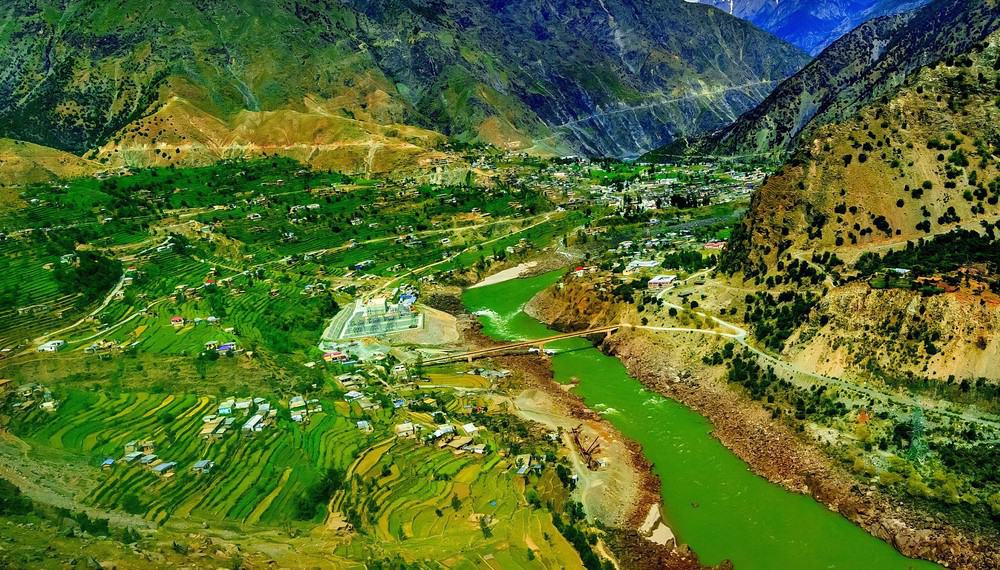
An aerial view of the Indus River valley in the Karakorum mountain range of the Basin. © khlongwangchao | Shutterstock
So how do we go about planning in a system that is in such constant flux?
Coping with system complexity in the Indus is the overarching theme of the third Indus Basin Knowledge Forum (IBKF) being co-hosted this week by the International Centre for Integrated Mountain Development (ICIMOD), the International Institute for Applied Systems Analysis (IIASA), the International Water Management Institute (IWMI), and the World Bank. Titled Managing Systems Under Stress: Science for Solutions in the Indus Basin, the Forum brings together researchers and other knowledge producers to interface with knowledge users like policymakers to work together to develop the future direction for the basin, while improving the science-decision-making relationship. Participants from four riparian countries–Afghanistan, China, India, and Pakistan–as well as from international organizations that conduct interdisciplinary research on factors that impact the basin, will work through a ‘marketplace’ for ideas, funding sources, and potential applications. The aim is to narrow down a set of practical and useful activities with defined outcomes that can be tracked and traced in coming years under the auspices of future fora.
The meeting builds on the work already done and, crucially, on relations already established in this complex geopolitical space, including under the Indus Forum and the Upper Indus Basin Network. By sharing knowledge, asking tough questions, and identifying opportunities for working together, the IBKF hopes to pin down concrete commitments from both funders and policymakers, but also from researchers, to ensure high quality outputs that are of real, practical relevance to this system under stress–from within and externally.
Scenario planning
Feeding into the IBKF3, and directly preceding the forum, the Integrated Solutions for Water, Energy, and Land Project (ISWEL) will bring together policymakers and other stakeholders from the basin to explore a policy tool that looks at how best to model basin futures. This approach will help the group conceive possible futures and model the pathways leading to the best possible outcomes for the most people. This ‘policy exercise approach’ will involve six steps to identify and evaluate possible future pathways:
- Specifying a ‘business as usual’ pathway
- Setting desirable goals (for sustainability pathways)
- Identifying challenges and trade-offs
- Understanding power relations, underlying interests, and their role in nexus policy development
- Developing and selecting nexus solutions
- Identifying synergies, and
- Building pathways with key milestones for future investments and implementation of solutions.
The summary of this scenario development workshop and a vision for the Indus Basin will be shared as part of the IBKF3 at the end of the event, and will help the participants collectively consider what actions can be taken to ensure a prosperous, sustainable, and equitable future for those living in the basin.
The rice that helps feed parts of East Africa plays a key global role–the challenge will be ensuring that this important trading relationship is not jeopardized by a system that moves from pressure points to eventual collapse. Open science-policy and decision-making collaboration are key to making sure that this does not happen.
This blog was originally published on https://wle.cgiar.org/thrive/2018/05/29/rice-and-reason-planning-system-complexity-indus-basin.
Note: This article gives the views of the author, and not the position of the Nexus blog, nor of the International Institute for Applied Systems Analysis.
Sep 19, 2017 | Citizen Science, Food, Sustainable Development
By Myroslava Lesiv, IIASA Ecosystems Services and Management Program.
The public can contribute considerably to science by filling the gaps of missing information in many research areas, for example, monitoring land use, biodiversity, or forest degradation. Crowdsourcing campaigns organized by research institutions bring together citizens interested in science and help solving research questions to the benefit of the whole world.
This June, the IIASA Geo-Wiki team ran the Global Field Size campaign, encouraging citizen scientists to classify field sizes on satellite images. Its aim was to develop a global field sizes dataset, which will be used as input to create an improved global cropland field size map for agricultural monitoring and food security assessments. The field sizes dataset can also help us determine what types of satellite data are needed for agricultural monitoring in different parts of the world.
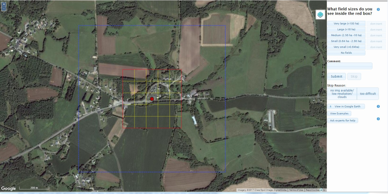
Geo-Wiki interface for collecting field size data. Background layer: Google Maps.
Why are field sizes so important? They provide us with valuable information to tackle challenges of food security. A recent study showed that more than a half the food calories produced globally comes from smallholder farmers, who often make up the most vulnerable parts of population, living in poverty. Within this scope, the field size dataset fills the gaps of missing information, especially for countries that have a limited food supply and lack a well-developed agricultural monitoring system.
The Global Field Size campaign has been one of the most successful crowdsourcing campaigns run through the Geo-Wiki engagement platform. Within one month, 130 participants completed 390,000 tasks – that is, they classified the field sizes in 130,000 locations around the globe!
So we can see that crowdsourcing is powerful, but can we trust the data? Is it accurate enough to be used in different applications? I think it is! The Geo-Wiki team has significant experience in running crowdsourcing campaigns; one of the key lessons we have learned from previous Geo-Wiki campaigns is the importance of training the public to increase the quality of the crowdsourced data.
This campaign was designed so that the participants learned over time how to delineate fields in different regions of the world, and, at the same time, pay special attention to the quality of their submissions. At the end of the campaign, the majority of participants gave us a feedback that, to them, this campaign was indeed a learning exercise. From our end, I have to add, this was also a challenging campaign, as fields are so diverse in shape, continuity of coverage, crop type, irrigation, etc.
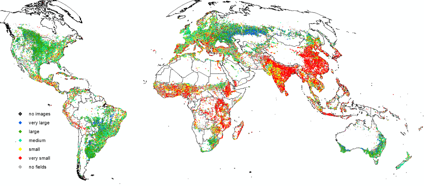
Global distribution of dominant field sizes. Cartography by Myroslava Lesiv. Country boundaries: GAUL. Software: ArcMap 10.1.
During the campaign, the crowd was asked to identify whether there were fields in a certain location, and determine the relevant field sizes by the visual interpretation of very high-resolution Google and Bing imagery. A “field” was defined as an agricultural area that included annual or perennial croplands, fallow, shifting cultivation, pastures or hayfields. The collected data can also be used to identify areas falsely mapped as cropland.
Now the team is focused on summarizing the results of the campaign, processing the collected field size data, and preparing them for scientific publication. We will ensure that the published dataset is of high quality and can be used by others with confidence!
This article gives the views of the author, and not the position of the Nexus blog, nor of the International Institute for Applied Systems Analysis.


You must be logged in to post a comment.