Nov 20, 2020 | Climate Change, Risk and resilience, Young Scientists
By Greg Davies-Jones, 2020 IIASA Science Communication Fellow
Greg Davies-Jones sits down with 2020 IIASA Young Scientists Summer Program (YSSP) participant Lisa Thalheimer to discuss how attribution science can play a leading role in addressing disaster displacement.
We live in the era of the greatest human movement in recorded history – there are more people on the move today than at any other point in our past. Despite the common misconception that most migrants cross borders, a lot of migration actually occurs internally. According to the Internal Displacement Monitoring Center, a staggering 72% of internal migration is linked to displacement due to natural hazards or extreme weather.
Pinpointing the finer details of how human mobility might evolve remains a complex undertaking. Contemporary migratory movements reflect the complex patterns of social and economic globalization – they flow in all directions and affect all countries in one way or another. It is clear that given the rising global average temperatures, natural hazards and extreme weather events will increase in frequency, intensity, and duration, adversely effecting many parts of the globe. A better understanding of how human-induced climate change influences disaster displacement will undoubtedly be essential in addressing future human mobility and informing the debate on climate and migration policies.
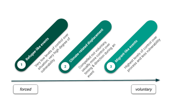
Figure: Climate-related displacement on an axis of forced to voluntary human mobility. Thalheimer (2020)
The focus of 2020 YSSP participant Lisa Thalheimer’s research is on internal displacement in East Africa, in particular, Somalia. As part of her YSSP project, Thalheimer hopes to determine whether, and to what extent, human-induced climate change altered the likelihood of extreme weather-related displacement in Somalia by conflating econometric methods and Probabilistic Event Attribution (PEA).
“Econometrics is essentially the application of statistical methods to quantify impacts and PEA is a way of examining to what extent extreme weather events can be linked with past man-made emissions. By combining the two methods we hope to quantify the ramifications of extreme weather and displacement in East Africa,” she explains.
This is no mean feat, as PEA itself is a relatively new science and many challenges still exist in the field of event attribution ̶ a field of research concerned with the process by which the causes of behavior and events can be explained. In this instance, the idea was to study each extreme weather event individually to determine if human-induced climate change may have added to the intensity or likelihood of the event occurring. PEA is a growing science within this field and relies on the availability of long-term meteorological observations and the reliability of climate model simulations. In terms of migration and the accompanying econometric methods, the complexity of this work is mainly in data capturing.
“The difficulty with migration data capturing is at the start – before you can capture anything, you must ascertain how the data is defined, as different countries define mobility in different ways. For instance, it could be time – where did you live one year ago as opposed to five years ago? That’s the first complexity. Then you must work out who collects data on who – in Europe, we have fundamental freedom of movement within the EU, so unless you file for residency, your movement is not recorded. Another complexity is because we want to see if climate change is part of the driver ̶ directly or indirectly. We need to know not just where people are now, but where they have been and where they came from, so we can match the climate with their movements. All of this highlights how difficult it is to carry out this type of analysis,” Thalheimer adds.
In Somalia, the team relied on previously collected forced migration data, for example, from the UN High Commissioner for Refugees (UNHCR). These UNHCR datasets collected in Somalia were comprehensive and included not only origin and destination information but also a categorization of the primary reason for the displacement.
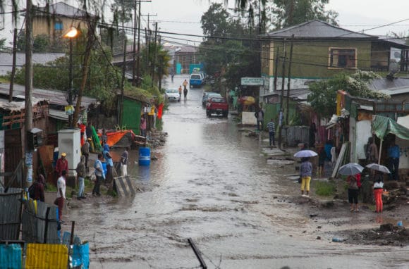
© Aleksandr Frolov | Dreamstime.com
The investigation homed in on one extreme weather case study in the region: The April 2020 heavy rainfall in Southern Ethiopia, which led to several severe flooding events in South Somalia. In this particular case, however, no appreciable connection could be made between human-induced climate change and the resultant displacement. Despite this somewhat chastening outcome, the achievement of this study is not proving a definitive attributable link between human-induced climate change and the April 2020 rainfall, but rather the construction of the adjustable attribution framework presented that can be applied directly to other events and displacement contexts.
As previously mentioned, there are, however, limitations to this novel methodology, especially in regions like Somalia that lack exhaustive observational weather and displacement data. According to Thalheimer, exploring ways of effectively applying this framework in countries vulnerable to climate change will be particularly important going forward.
“Event attribution studies do not usually form the basis of climate migration analysis, disaster risk reduction, or adaptation strategies. Yet, to respond appropriately to these impacts and affected populations, we must develop a comprehensive and detailed understanding of the nature of these impacts, as well as knowledge on how these might evolve over time. Event attribution is a tool we can employ to do this,” she concludes.
Note: This article gives the views of the author, and not the position of the Nexus blog, nor of the International Institute for Applied Systems Analysis.
Mar 29, 2019 | USA, Young Scientists
By Matt Cooper, PhD student at the Department of Geographical Sciences, University of Maryland, and 2018 winner of the IIASA Peccei Award
I never pictured myself working in Europe. I have always been an eager traveler, and I spent many years living, working and doing fieldwork in Africa and Asia before starting my PhD. I was interested in topics like international development, environmental conservation, public health, and smallholder agriculture. These interests led me to my MA research in Mali, working for an NGO in Nairobi, and to helping found a National Park in the Philippines. But Europe seemed like a remote possibility. That was at least until fall 2017, when I was looking for opportunities to get abroad and gain some research experience for the following summer. I was worried that I wouldn’t find many opportunities, because my PhD research was different from what I had previously done. Rather than interviewing farmers or measuring trees in the field myself, I was running global models using data from satellites and other projects. Since most funding for PhD students is for fieldwork, I wasn’t sure what kind of opportunities I would find. However, luckily, I heard about an interesting opportunity called the Young Scientists Summer Program (YSSP) at IIASA, and I decided to apply.
Participating in the YSSP turned out to be a great experience, both personally and professionally. Vienna is a wonderful city to live in, and I quickly made friends with my fellow YSSPers. Every weekend was filled with trips to the Alps or to nearby countries, and IIASA offers all sorts of activities during the week, from cultural festivals to triathlons. I also received very helpful advice and research instruction from my supervisors at IIASA, who brought a wealth of experience to my research topic. It felt very much as if I had found my kind of people among the international PhD students and academics at IIASA. Freed from the distractions of teaching, I was also able to focus 100% on my research and I conducted the largest-ever analysis of drought and child malnutrition.
© Matt Cooper
Now, I am very grateful to have another summer at IIASA coming up, thanks to the Peccei Award. I will again focus on the impact climate shocks like drought have on child health. however, I will build on last year’s research by looking at future scenarios of climate change and economic development. Will greater prosperity offset the impacts of severe droughts and flooding on children in developing countries? Or does climate change pose a hazard that will offset the global health gains of the past few decades? These are the questions that I hope to answer during the coming summer, where my research will benefit from many of the future scenarios already developed at IIASA.
I can’t think of a better research institute to conduct this kind of systemic, global research than IIASA, and I can’t picture a more enjoyable place to live for a summer than Vienna.
Note: This article gives the views of the author, and not the position of the Nexus blog, nor of the International Institute for Applied Systems Analysis.
Aug 7, 2017 | Climate Change, Food & Water, Water, Young Scientists
By Parul Tewari, IIASA Science Communication Fellow 2017
In 2016, Bolivia saw its worst drought in nearly 30 years. While the city of La Paz faced an acute water shortage with no piped water in some parts, the agricultural sector was hit the hardest. According to The Agricultural Chamber of the East, the region suffered a loss of almost 50% of total produce. Animal carcasses lay scattered in plain sight in the valleys, where they had died looking for watering holes.
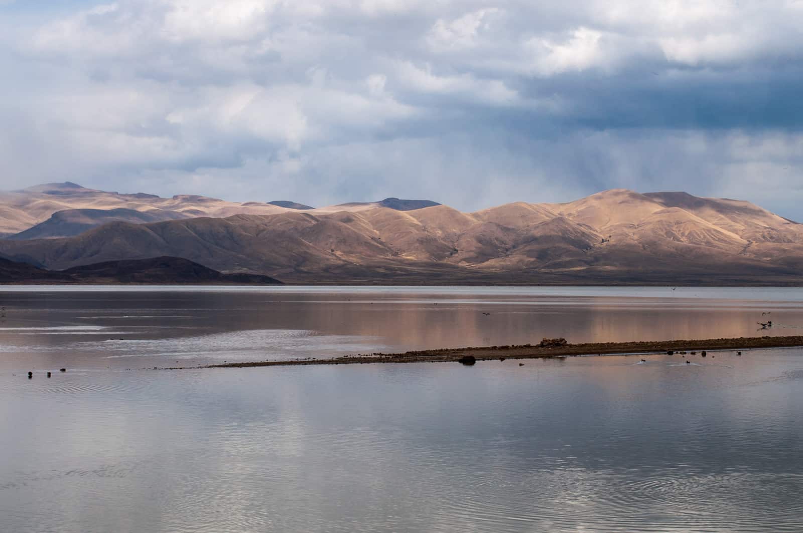
Lake Poopo (Bolivia) before it dried up © David Almeida I Flickr
One of the most dramatic results of this catastrophic drought was that Lake Poopo, (pronounced po-po) Bolivia’s second largest lake was drained of every drop of water. Located at a height of approximately 1127 meters, and covering an area of 1,000 square kilometers, what remains of it now resembles a desert more than a lake. This event forced the fishing community of Uru Uru, which depended on the lake, to either migrate to other lakes or look for alternate livelihood options.
Lake Poopo is located in the central South American Altiplano, one of the largest high plateaus in the world (Bolivia’s largest lake, Titicaca, is located in the north of the region). Due to its unique topography, the highland faces extreme climatic conditions, which are responsible for difficult lives as well as widespread poverty among the people who live there.
While Titicaca is over 100 meters deep, Poopo had a depth of less than three meters. Combined with a high rate of evapotranspiration, erratic rainfall, and limited flow of water from the Desaguadero River, Poopo was in a precarious position even during the best of times. Whatever little water flowed in from the river is further depleted by intensive irrigation activities at the south of Lake Titicaca before the water makes it way down to Poopo.
Sattelite images of Lake Poopo
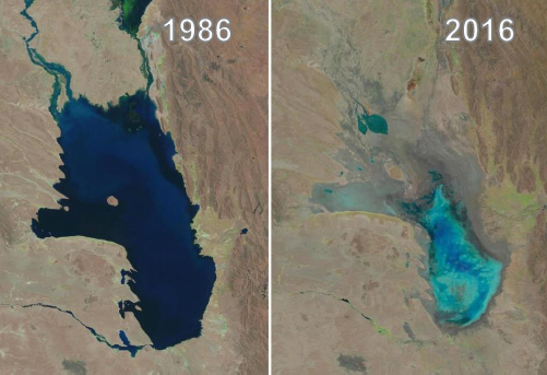
Changes in water levels of Lake Poopo over 30 years © U.S. Geological Survey, Associated Press
The lake’s existence had been threatened several times in the past. However, the 2016 drought was one of the most devastating ones. According to the Defense Ministry of Bolivia, early this year the lake started recovering after several days of heavy rain, restoring as much as 70% of the water. However, since the lake is a part of a very fragile ecosystem, there have been some irreversible changes to the flora and fauna in addition to the losses to the fishing communities living around the lake.
Charting a better future
Claudia Canedo, a participant of the 2017 Young Scientists Summer Program (YSSP) at IIASA, is exploring the impact of droughts and the risk on agricultural production in the light of this event, after which Bolivia declared a state of water emergency. Canedo was born and raised in the city of La Paz and experienced water shortages while growing up close to the Altiplano. This motivated her to investigate a sustainable solution for water availability in the region. With the results of her study she is hoping to ensure that such a situation doesn’t arise again in the Altiplano – that other communities directly dependent on ecosystem services, like that of Lake Poopo, do not have to lose everything because of an extreme weather event.
For a region where more than half the population is dependent on agriculture for their livelihoods, droughts serve as a major setback to the national economy. “It is not just one factor that led to the drought, though. There were different factors that contributed to the drying up of the lake and also contribute to the agricultural distress,” she says.
“The southern Altiplano lies in an arid zone and receives low precipitation due to its proximity to the Atacama Desert. Poor soil quality (high saline content and lack of nutrients) makes it unsuitable for most crops, except quinoa and potato in some areas,” adds Canedo. Residents also lack the knowledge and the monetary resources to invest in newer technology, which could possibly lead to better water management.
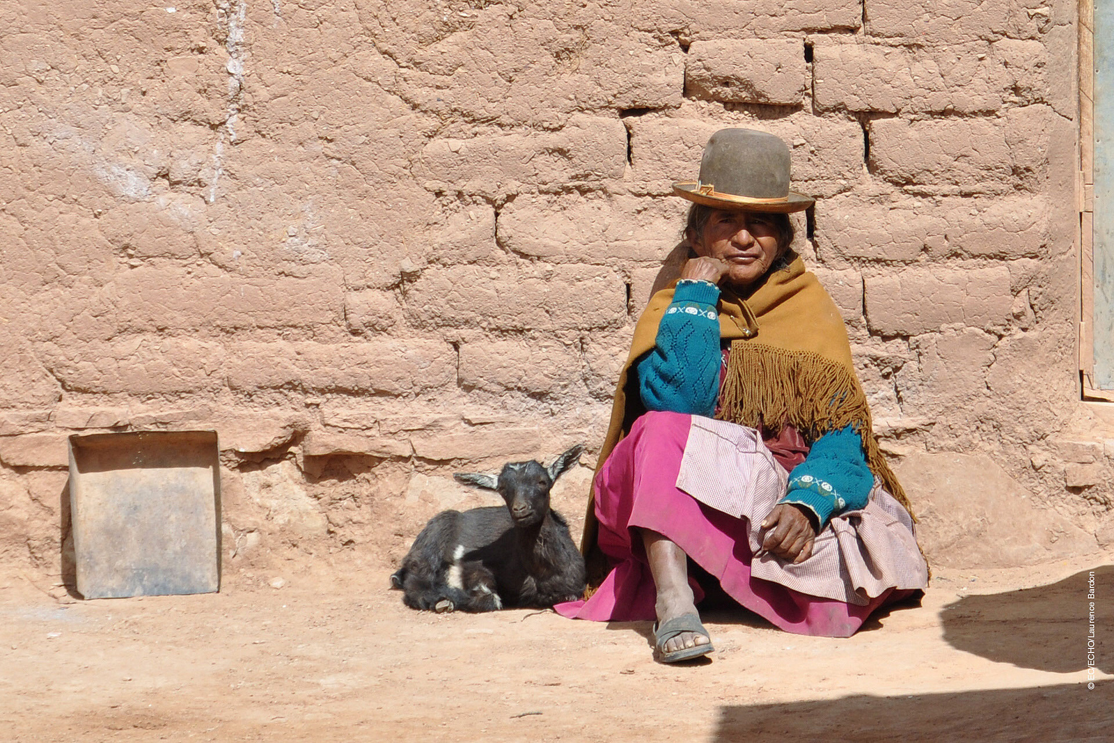
A woman from one of the drought affected communities in Bolivia © EU – Photo credits: EC/ECHO/Laurence Bardon I Flickr
One of the most critical factors in the recent drought was the El Nino- Southern Oscillation, the warming of the sea temperatures in the Pacific Ocean, which in turn carries the warmer oceanic winds and lowers the rate of precipitation in the highland leading to increased evapotranspiration. In 2015 and 2016, the losses due to this phenomenon were devastating for agriculture in the Altiplano, says Canedo.
In her quest to find solutions, the biggest challenge is the lack of recorded data from local weather stations for the past years. Although satellite data is available, it is too generic in nature to do a local analysis. Therefore combining ground and satellite data could enhance the present knowledge and provide consistent results of the climate and vegetation variability. If done successfully, Canedo hopes to identify a correlation between precipitation and vegetation. With this information, she can improve climate forecasting that could help the local people adapt to droughts powerful enough to turn their lives upside down.
With weather forecasts and early warning systems for extreme weather events like droughts, farmers would know what to expect and would be able to plant resilient varieties of crops. This might not earn them the same profits as in a normal year, but would not result in a failed crop. Claudia aims to come up with a drought index useful for drought monitoring and early warning, which will integrate short-term and long-term meteorological predictions.
Perhaps, in the future, with this newfound knowledge, the price for extreme weather events won’t be paid in terms of lost ecosystems like that of Lake Poopo, robbing people of their lives and livelihoods.
About the Researcher
Claudia Canedo is a participant in the 2017 IIASA YSSP. She is pursuing a doctoral program in water resources engineering at Lund University, Sweden. She is interested in studying the hydrological and climatological conditions over small basins in the South American highlands. The aim of her research is to define water resources availability and find strategies for sustainable water management in the semi-arid region.
This article gives the views of the author, and not the position of the Nexus blog, nor of the International Institute for Applied Systems Analysis.
Jul 26, 2017 | Alumni, Climate Change, Poverty & Equity, Sustainable Development, Water, Young Scientists
Adil Najam is the inaugural dean of the Pardee School of Global Studies at Boston University and former vice chancellor of Lahore University of Management Sciences, Pakistan. He talks to Science Communication Fellow Parul Tewari about his time as a participant of the IIASA Young Scientists Summer Program (YSSP) and the global challenge of adaptation to climate change.
How has your experience as a YSSP fellow at IIASA impacted your career?
The most important thing my YSSP experience gave me was a real and deep appreciation for interdisciplinarity. The realization that the great challenges of our time lie at the intersection of multiple disciplines. And without a real respect for multiple disciplines we will simply not be able to act effectively on them.
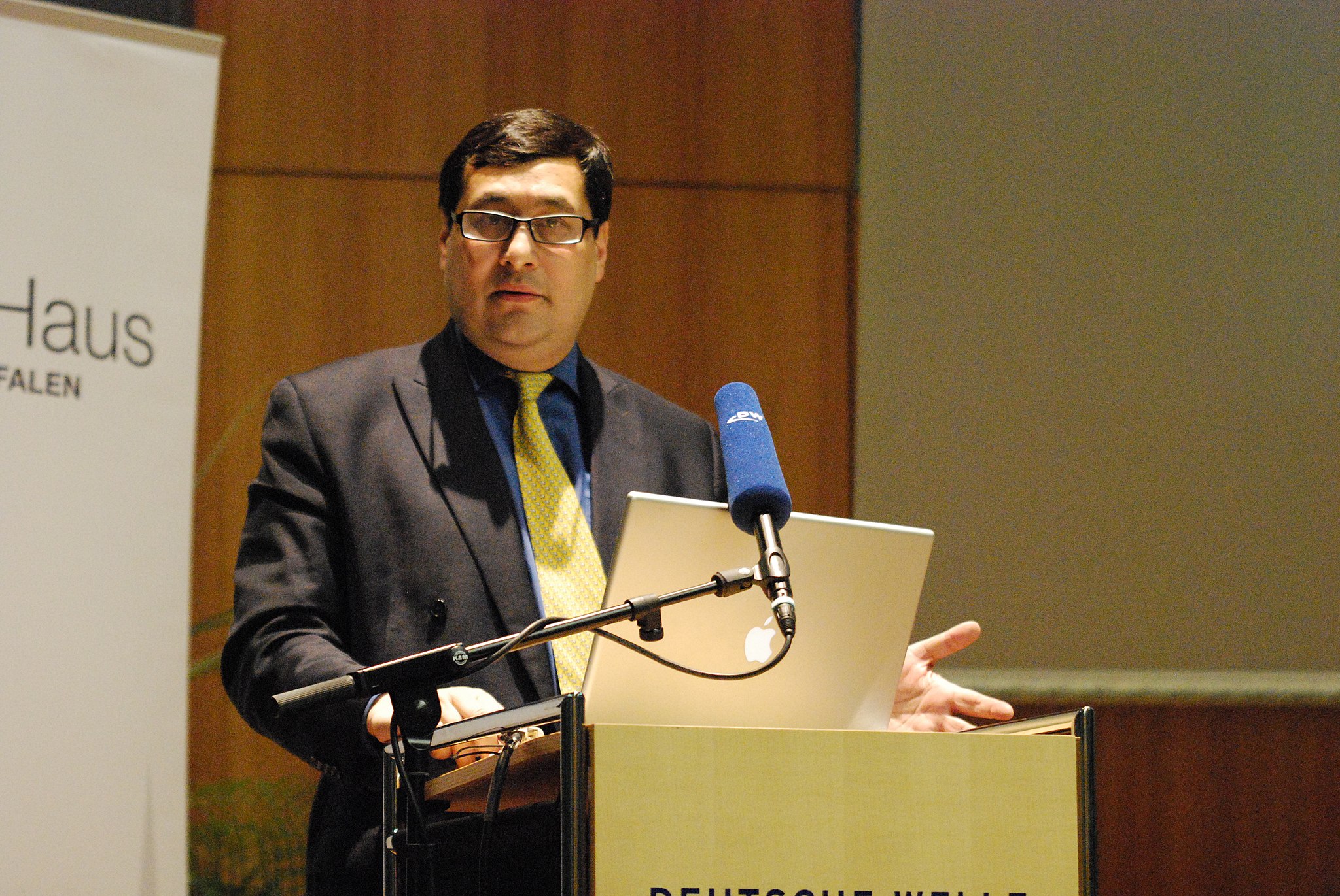
Prof. Adil Najam speaking at the Deutsche Welle Building in Bonn, Germany in 2010 © Erich Habich I en.wikipedia
Recently at the 40th anniversary of the YSSP program you spoke about ‘The age of adaptation’. Globally there is still a lot more focus on mitigation. Why is this?
Living in the “Age of Adaption” does not mean that mitigation is no longer important. It is as, and more, important than ever. But now, we also have to contend with adaptation. Adaptation, after all, is the failure of mitigation. We got to the age of adaptation because we failed to mitigate enough or in time. The less we mitigate now and in the future, the more we will have to adapt, possibly at levels where adaptation may no longer even be possible. Adaption is nearly always more difficult than mitigation; and will ultimately be far more expensive. And at some level it could become impossible.
How do you think can adaptation be brought into the mainstream in environmental/climate change discourse?
Climate discussions are primarily held in the language of carbon. However, adaptation requires us to think outside “carbon management.” The “currency” of adaptation is multivaried: its disease, its poverty, its food, its ecosystems, and maybe most importantly, its water. In fact, I have argued that water is to adaptation, what carbon is to mitigation.
To honestly think about adaptation we will have to confront the fact that adaptation is fundamentally about development. This is unfamiliar—and sometimes uncomfortable—territory for many climate analysts. I do not believe that there is any way that we can honestly deal with the issue of climate adaptation without putting development, especially including issues of climate justice, squarely at the center of the climate debate.
COP 22 (Conference of Parties) was termed as the “COP of Action” where “financing” was one of the critical aspects of both mitigation and adaptation. However, there has not been much progress. Why is this?
Unfortunately, the climate negotiation exercise has become routine. While there are occasional moments of excitement, such as at Paris, the general negotiation process has become entirely predictable, even boring. We come together every year to repeat the same arguments to the same people and then arrive at the same conclusions. We make the same promises each year, knowing that we have little or no intention of keeping them. Maybe I am being too cynical. But I am convinced that if there is to be any ‘action,’ it will come from outside the COPs. From citizen action. From business innovation. From municipalities. And most importantly from future generations who are now condemned to live with the consequences of our decision not to act in time.
© Piyaset I Shutterstock
What is your greatest fear for our planet, in the near future, if we remain as indecisive in the climate negotiations as we are today?
My biggest fear is that we will—or maybe already have—become parochial in our approach to this global challenge. That by choosing not to act in time or at the scale needed, we have condemned some of the poorest communities in the world—the already marginalized and vulnerable—to pay for the sins of our climatic excess. The fear used to be that those who have contributed the least to the problem will end up facing the worst climatic impacts. That, unfortunately, is now the reality.
What message would you like to give to the current generation of YSSPers?
Be bold in the questions you ask and the answers you seek. Never allow yourself—or anyone else—to rein in your intellectual ambition. Now is the time to think big. Because the challenges we face are gigantic.
Note: This article gives the views of the interviewee, and not the position of the Nexus blog, nor of the International Institute for Applied Systems Analysis.
May 29, 2017 | Citizen Science, Risk and resilience
By Wei Liu, IIASA Risk and Resilience Program
What do Rajapur, Nepal; Chosica, Peru; and Tabasco, Mexico all have in common? Flooding: these areas are all threatened by floods, and they also face similar knowledge gaps, especially in terms of local level spatial information on risk, and the resources and the capacities of communities to manage risk.
To address these gaps, I and my colleagues at IIASA, in collaboration with Kathmandu Living Labs (KLL) and Practical Action (PA) Nepal are building on our experiences in Nepal’s Lower Karnali River basin to support flood risk mapping in flood-prone areas in Peru and Mexico.
Recent developments in data collection and communication via personal devices and social media have greatly enhanced citizens’ abilities to contribute spatial data, called Crowdsourced Geographic Information (CGI) in the mapping community. OpenStreetMap is the most widely used platform for sharing this free geographic data globally, and the fast growing Humanitarian OpenStreetMap Team has developed CGI in some of the world’s most disaster-prone and data-scarce regions. For example, after the 2015 Nepal Earthquake, thousands of global volunteers mapped infrastructure across Nepal, greatly supporting earthquake rescue, recovery, and reconstruction efforts.
Today there is excellent potential to engage citizen mappers in all stages of the disaster risk management cycle, including risk prevention and reduction, preparedness and reconstruction. In this project, we have successfully launched a series of such mapping activities for the Lower Karnali River basin in Nepal starting in early 2016. In an effort to share the experience and lessons of this work with other Zurich Global Flood Resilience Alliance field sites, in March 2017 we initiated two new mapathons in Kathmandu, with support from Soluciones Prácticas (PA Peru) and the Mexican Red Cross, to remotely map basic infrastructure such as buildings and roads, as well as visible water surface, around flood-prone communities in Chosica, Peru and Tobasco, Mexico.
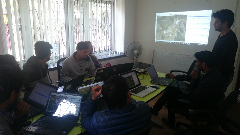
March 17th, 2017, staff and volunteers conducting remote mapping at Kathmandu Living Labs @ Wei Liu | IIASA
Prior to our efforts very few buildings in these areas were identified on online map portals, including Google Maps, Bing Maps, and OSM. Through our mapathons, dozens of Nepalese volunteers mapped over 15,000 buildings and 100 km of roads. The top scorer, Bishal Bhandari, mapped over 1,700 buildings and 6 km of roads for Chosica alone.
Having the basic infrastructure mapped before a flood event can be extremely valuable for increasing flood preparedness of communities and for local authorities and NGOs. During the period of the mapathons, the Lima region in Peru, including Chosica, was hit by a severe flood induced by coastal El Niño conditions. Having almost all buildings in Chosica mapped on the OSM platform now makes visible the high flood risk faced by people living in this densely populated area with both formal and informal settlements. These data may support conducting a quick damage assessment, as suggested by Miguel Arestegui, a collaborator from PA Peru during his visit to IIASA in April, 2017.
Recognizing the value of crowdsourced spatial risk information, we are working closely with partners, including OpenStreetMap Peru, to mobilize the creativity, technical know-how, and practical experience from the Nepal study to Latin America countries. Collecting such information using CGI comes with low cost but high potential for modeling and estimating the amount of people and economic assets potentially being affected under different future flood situations, for improving development and land-use plans to support disaster risk reduction, and for increasing preparedness and helping with allocating humanitarian support in a timely manner after disaster events.
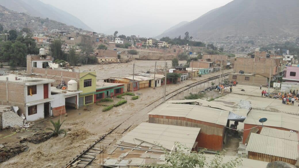
Flood-inundated houses and local railway in Chosica, Peru, 18/03/2017 @ Miluska Ordoñez | Soluciones Prácticas
The United Nation’s Sendai Framework for Disaster Risk Reduction states that knowledge in “all dimensions of vulnerability, capacity, exposure of persons and assets, hazard characteristics and the environment” needs to be leveraged to inform policies and practices across all stages of the disaster risk management cycle. CGI has a great potential to involve citizens from around the world to help fill this critical knowledge gap. These pilot mapathons conducted between Nepal and Latin America are promising examples of supporting community flood resilience through the mobilization of CGI via international partnerships within the Global South.
This article gives the views of the author, and not the position of the Nexus blog, nor of the International Institute for Applied Systems Analysis.

You must be logged in to post a comment.