Dec 5, 2016 | Climate Change, Environment, Sustainable Development
By Alvaro Silva Iribarrem, researcher in the IIASA Ecosystems Services and Management Program.
Restoration of degraded ecosystems is an exciting and relatively new way of looking into the conservation of natural capital—the world’s natural assets, including soil, air, water, and all living things. For one, the success of restoration is more readily verifiable than, for example, avoided degradation. Further, it increases the landscape’s resilience: natural areas can be placed around agricultural crops, increasing their yields by providing habitat for pollinators and therefore increasing pollination, protecting them from natural disasters, and improving the provision of important ecosystem services for human wellbeing.
These services include removing CO2 from the atmosphere (which contributes directly to climate change mitigation); ensuring that more sediment is filtered from the rivers (which reduces the risk of landslides and floods); and providing habitat for a large diversity of species. For scientists, it feels like being at the head of the counter-offensive: it is us, humans, finally doing something not only to slow our seemingly unstoppable degradation of the environment, but to actively start pushing it back.
Restoring an ecosystem to its original state can be an expensive endeavor, but tropical rainforests are very resilient. For example, even after centuries of extensive use of the Brazilian Atlantic Forest, which has been reduced to a tenth of its size, in many places it would still grow back to much of its original state in a manner of decades, if allowed to do so. For such ecosystems, natural regeneration represents an extraordinary opportunity to enable restoration at scales that would otherwise be cost-prohibitive.
In places like the Paraitinga watershed, in the countryside of São Paulo state, most of the original forest has long been cleared, and replaced, predominantly, by small dairy farms. After over a century of careless land use, large areas of the converted landscape has degraded to the point where yields are so low that farms are barely viable. The lack of forest cover has led to frequent floods. The worst of the recent ones, in 2010, destroyed most of the historical city of São Luiz do Paraitinga, with a population of 11 thousand inhabitants.
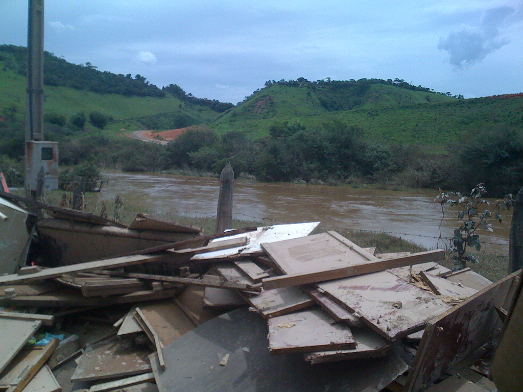
The aftermath of the 2010 flood in Paraitinga. © Luciano Dinamarco
In a couple of recent publications, we made a comprehensive effort to include the natural regeneration of that watershed’s native forest as part of a bigger plan for more sustainable development of the region, one that would increase its resilience to this kind of disaster.
Starting from a landscape approach, we looked at the potential for grass growth in the region, and concluded that it was possible to accommodate all foreseeable future demands for cattle production and still make space for the restoration of a large area in the watershed. Sustainable intensification of current pasture is key to avoid the economic losses that could otherwise follow the land shortage caused by such a large-scale restoration. It would also help to gain the farmers’ acceptance. By producing more in a smaller area, they could let go of the degraded areas they currently use, allowing the native forest fragments nearby to spread.
In our regeneration scenario, we assume that around 24,000 hectares of pastureland that is presently abandoned in the watershed will be allowed to undergo natural regeneration in the next 20 years. This naturally occurring forest regrowth would sequester 6.2 million tons of CO2 from the atmosphere. Additionally, it would reduce sediment load into rivers by 570,000 tons annually, bringing water purification costs in the area down by 0.37 dollars per year per hectare restored. Finally we showed that restoration of even this relatively small area would be enough to significantly increase habitat availability for all species, particularly for those which travel between forest fragments.
To understand the difficulties farmers face in improving productivity, we conducted interviews and focus groups with them. We found that the tendency to keep to their old, low-producing, land-extensive ways, is less related to a resistance to change, and more to a lack of technical knowledge and the means to make the upfront investments needed to switch to a more productive system. Credit for investment is available and cheap in the country, but only a small number of farmers in the region risk taking it. Technical assistance is key to tap into these resources and enable the necessary improvement of the watershed’s production. The conditions for unlocking large-scale forest regrowth, not only in the Paraitinga watershed but in many similar landscapes in the country, are in place—they need only to be implemented properly.
Strassburg BB, Barros FS, Crouzeilles R, Silva Iribarrem, A, dos Santos JS, Silva D, Sansevero JB, Alves-Pinto H, Feltrain-Barbieri R, & Latawiec AE (2016). The role of natural regeneration to ecosystem services provision and habitat availability: a case study in the Brazilian Atlantic Forest. Biotropics.
Alves-Pinto HN, Latawiec AE, Strassburg BBN, Barros FSM, Sansevero JBB, Iribarrem A, Crouzeilles R, Lemgruber LC, Rangel M, & Silva ACP (2016). Reconciling rural development and ecological restoration: Strategies and policy recommendations for the Brazilian Atlantic Forest. Land Use Policy.
This article gives the views of the author, and not the position of the Nexus blog, nor of the International Institute for Applied Systems Analysis.
Apr 7, 2016 | Environment
By Andrey Krasovskii, IIASA Ecosystems Services and Management Program
By 2090, the area burned by forest fires in the European Union could increase by 200% because of climate change. However, preventive fires could keep that increase to below 50%. Improved firefighting response could provide additional protection against forest fires. These findings were the result of modeling work we did for the EU Mediation project on projecting future burned areas and adaptation options in Europe. When we talk about these results, people often want to know more about how our model works, what assumptions it makes, and how reliable it is.
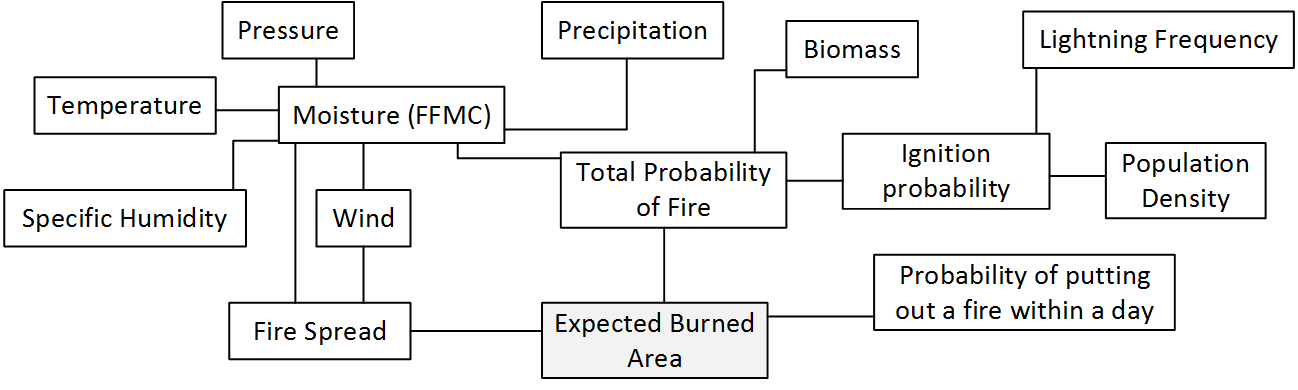
Figure 1. The WildFire cLimate impacts and Adaptation Model (FLAM) schematic – estimation of expected burned area.
The model is complex: every link in the schematic shown above represents a specific mathematical formula. These formulas have been developed by many researchers who studied how wildfire occurrence is related to climate, population, and biomass available for burning. Their results have been aggregated into mathematical relations and functions attempting to replicate real processes. The model code runs through the scheme with daily weather inputs in order to calculate the potential for fire ignition, spread, and burned areas. The model transforms spatial and intertemporal inputs into expected burned areas for 25km squares across the entirety of Europe. These squares can be summed up into geographic regions, e.g. countries, as well as burned areas can be aggregated over a given time period, e.g. 10 years.
It took days for our colleague Mirco Migliavacca to run the model during his work at the Joint Research Center of the European Commission. In fact, the scheme depicted in Figure 1 shows only a small piece of a larger picture reflecting the Community Land Model with the integrated fire module (CLM-AB), which he used. CLM-AB calculates all inputs in the indicated fire module, based on modeling processes in the global vegetation system. To speed up the running times for the case study focused on the wildfires in Europe, my colleague Nikolay Khabarov developed a standalone version of the fire model by decoupling the fire module from CLM-AB. When I joined the study, we had also found alternatives for input data, e.g. IIASA’s Global Forest Database, and implemented additional procedures in order to create our wildfire climate impacts and adaptation model (FLAM).
We used the historical data from satellite observations in order to validate modeling results. At the beginning many numerical experiments in CLM and FLAM did not give satisfactory results – there was either overestimation or underestimation of modeled burned areas compared to those reported in available datasets. One day a purely mathematical insight happened. We realized that in the fire algorithm implemented in FLAM, there is a parameter that can be factorized, mathematically speaking. This parameter, a probability of extinguishing a fire in a pixel in one day, was constant for Europe and set to 0.5. It became obvious that this parameter should vary with respect to a region. Factorization of this variable gave a possibility to avoid routine calculations, and use it for calibrating the model over a historical period. This can be done analytically by solving a corresponding polynomial equation. Analytical findings allowed us to introduce an effective calibration procedure and at the same time to estimate a firefighting efficiency on a country level. Further, using the advice of our colleagues Anatoly Shvidenko and Dmitry Schepaschenko, we have introduced adaptation options in the model, for example prescribed burnings, which firefighters use to reduce the fuel availability and, consequently, potential of a major fire.
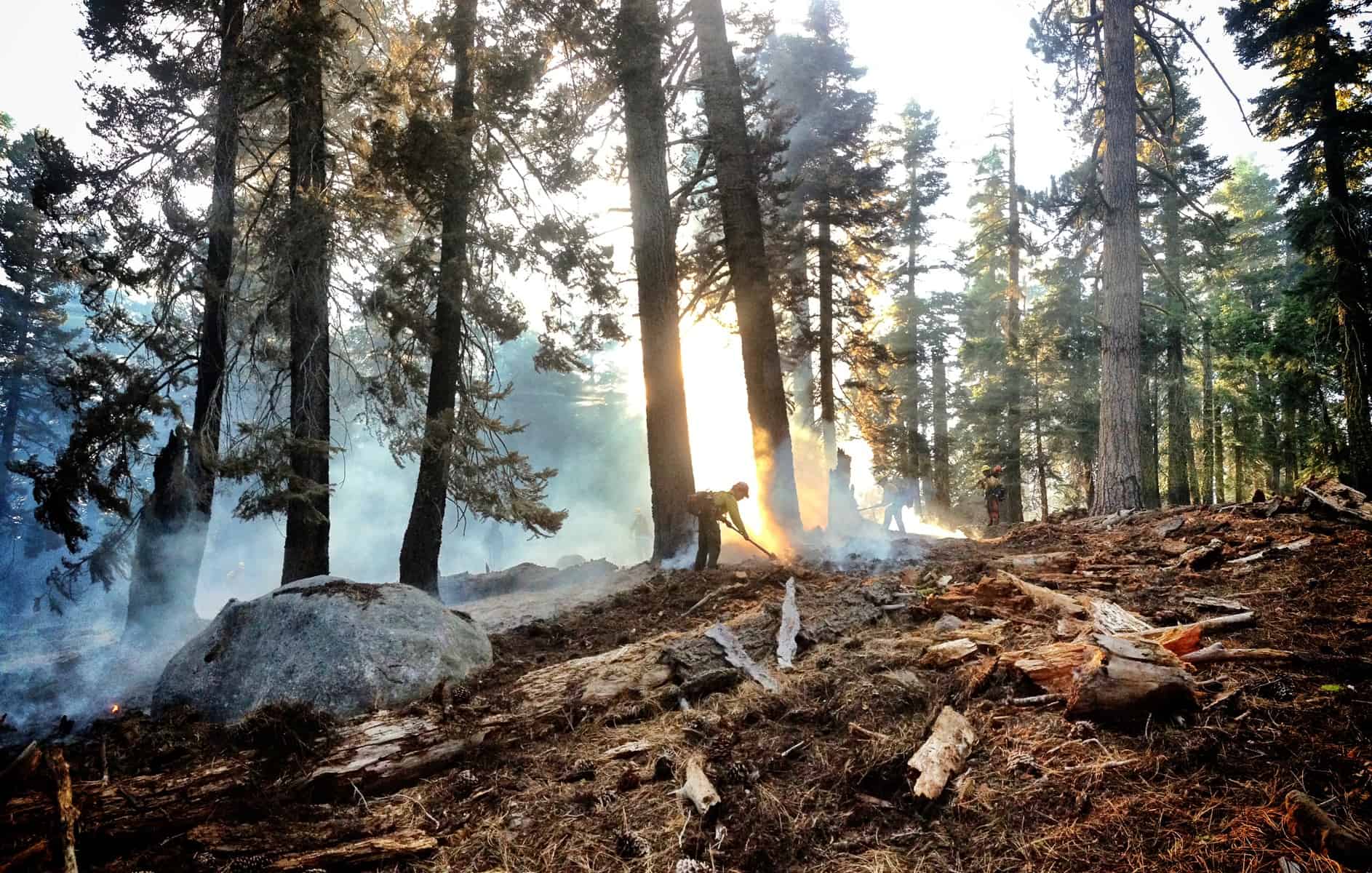
Prescribed burnings are one tool that can help prevent major wildfires. (cc) US Bureau of Land Management via Flickr
Once we had calibrated the model so that it adequately performed on the historical period (using historical climate data), we used climate scenarios to produce future projections. Currently, we are working on further improvements in modeling accuracy in annual burned areas by introducing additional regionally specific factors in the model. In the recent study published in the International Journal of Wildland Fire, we suggested improving the original model by modifying the fire probability function reflecting fuel moisture. This modification allows for a dramatic improvement of accuracy in modelled burned areas for a range of European countries.
Despite some success in modeling annual burned areas in Europe, we still have difficulties in predicting the extreme fires, in particular in some more arid and hence vulnerable regions such as Spain. However, we accept the challenge, because credible modeling results in terms of burned areas provide important information for assessing economic damages and CO2 emissions, due to climate and human activities. Our research has the potential to help society to realize these risks and undertake preventive measures. It also delivers an additional scientific value due to the fact, that fire risks must be included in forest management models.
I would like to thank all the study co-authors for their valuable contributions and efficient collaboration.
Reference
Krasovskii, A., Khabarov, N., Migliavacca, M., Kraxner, F. and Obersteiner, M. (2016) Regional aspects of modelling burned areas in Europe. International Journal of Wildland Fire. http://dx.doi.org/10.1071/WF15012
Note: This article gives the views of the interviewee, and not the position of the Nexus blog, nor of the International Institute for Applied Systems Analysis.
Mar 15, 2016 | Alumni, Environment, Young Scientists
By Carlijn Hendriks, Netherlands Organization for Applied Scientific Research (TNO) & IIASA Peccei award winner
Last summer, I participated in IIASA’s Young Scientist Summer Program, working with the Mitigation of Air Pollution and Greenhouse Gases and Ecosystems Services and Management programs. My research focused on what impacts the EU climate and air quality policy could have on ground level ozone around the middle of this century. While clean air policies should help reduce the pollution that can lead to ozone formation, we found that that climate change and energy policies will still increase ozone concentrations and damage by mid-century, unless stricter air pollution measures are implemented.

Ozone forms through reactions of various pollutants and chemicals in the atmosphere – a process that speeds up at higher temperatures. © Damián Bakarcic via Flickr
Ozone at ground level is an air pollutant, causing health and ecosystem problems. It is also an important component of summer smog. Ozone is not emitted into the atmosphere directly, but is produced when volatile organic carbons are oxidized in the presence of nitrogen oxides and light. Nitrogen oxides are released into the atmosphere mainly as a result of combustion processes (like car engines and industry), while non-methane volatile organic carbons (NMVOCs) come in large part from vegetation, especially broad-leaf trees and some fast-growing crops.
Part of the EU energy policy is to stimulate the use of sustainable biomass as an energy source. This could lead to expansion of commercial bioenergy crop production in plantations and an increasing use of forests. While this may help to reduce greenhouse gas emissions, it will also increase NMVOC emissions. At the same time, EU air quality policies aim to reduce emissions of air pollutants such as nitrogen oxides and man-made NMVOC. Because some steps in the ground level ozone formation process are driven by absorption of light and/or proceed faster with higher temperatures, climate change could lead to higher ground level ozone concentrations in the future.
The separate effects of these three trends on ground level ozone have been studied before, but the question remains: what will be the combined impact of a) an increase of bioenergy plantations, b) EU’s air quality policy and c) climate change on health and ecosystem damage from ground level ozone? And which of the trends is the most important? To answer these questions, I used three models to study two energy and air quality scenarios for Europe under current and possible future climate conditions.
Two energy scenarios calculated by the Price-Induced Market Equilibrium System (PRIMES) model form the basis of this work. We used a reference scenario and one in which Europe reaches 80% CO2 emission reduction in 2050. These energy scenarios were used as a basis to calculate air pollutant emissions with IIASA’s Greenhouse Gas and Air Pollution Interactions and Synergies (GAINS) model. Then we put the same scenarios into IIASA’s Global Biosphere Model GLOBIOM to obtain the change in land cover because of increasing bioenergy demand. I combined these datasets in chemistry transport model LOTOS-EUROS (the model of choice at my home institute, TNO) to calculate the impact on ground level ozone concentrations across Europe. To simulate ‘future climate’ we used the year 2003, in which Europe had a very warm summer, with temperatures 2-5 °C higher than normal.
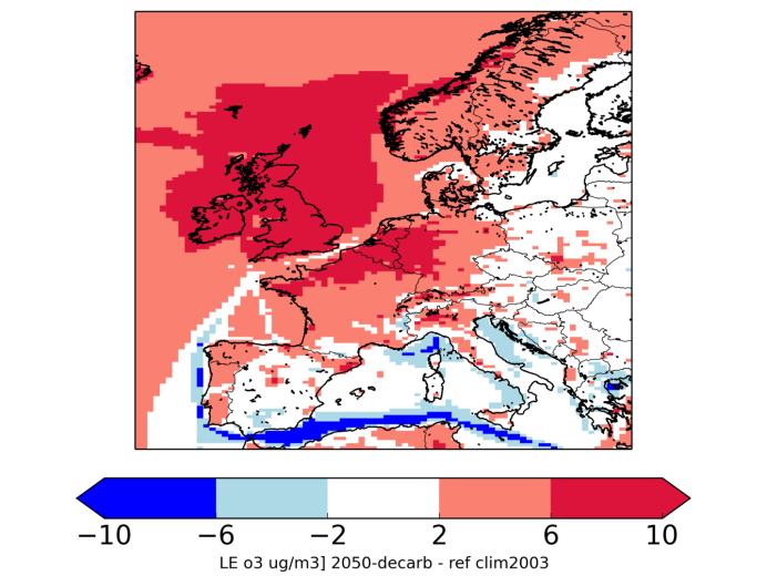
Difference in average ozone concentration (in µg/m3) between the current situation and the 80% CO2 reduction scenario in 2050 under future climate change conditions for the period April-September. Negative numbers mean a decrease in ozone levels.
We found that especially for the CO2-reduction scenario, the increase in bioenergy production could cause a slight increase in ozone damage. However, the impact of reduced emissions because of more stringent air quality policies far outweighs this effect, leading to a net reduction of ozone damage. The third effect, more efficient ozone formation in a warming climate, is so strong that in 2050 ozone damage to human health could be worse than today, especially for northwestern Europe. Stringent air quality policies close to a maximum feasible reduction scenario would be needed to make sure that health and ecosystem damage towards the middle of the century is smaller than it is today.
Note: This article gives the views of the author, and not the position of the Nexus blog, nor of the International Institute for Applied Systems Analysis.
Nov 2, 2015 | Environment
By Ping Yowargana, IIASA Ecosystems Services and Management Program
Recently, Indonesia has been combating its most severe forest fire of the decade. Around 43 million Indonesians have been exposed to hazardous fumes, and countless loss of biodiversity and ecosystem services has occurred. An estimated 1 billion tonnes of carbon emission has been released to the atmosphere. Within three months, Indonesia’s daily carbon emission has surpassed the average daily emissions of the whole US economy.

Firefighters outside Palangka Raya, Central Kalimantan, 15 October 2015.
Photo by Aulia Erlangga/ CIFOR
Forest fires in Indonesia are closely related to unsustainable agricultural practices spreading out throughout the country. Indonesia is the world’s largest producer of palm oil, with 8 million hectares of plantation area. Other than its significant contribution to the economy, and broadly debated effects on the environment, oil palm is also regarded as a promising solution to the country’s effort to achieve energy security. The current administration has set ambitious targets to increase national biofuel production, and to consume it domestically.
In this landscape of uncertainty and crisis, scientific support for Indonesian energy policy is more urgently needed than ever. That’s why it is one of our main focuses in the IIASA Tropical Forests Initiative (TFI).
“Scientific authority has to be the basis of our future energy policies,” said Mr. Sudirman Said, Indonesia’s Minister of Energy and Mineral Resources, at the opening session of our first collaborative screening workshop in September in Bandung, Java. In the workshop, jointly organized by IIASA and the ministry, we aimed at laying out a plan to establish a new decision support system for the ministry, based on IIASA’s energy systems models such as the renewable energy systems optimization model, BeWhere and the Model for Energy Supply Strategy Alternatives and their General Environmental Impact (MESSAGE).
Scientific decision support systems (DSS) are a tangible crystallization of bridging science to policy. A decision support system gathers information and analytical expertise in order to improve the quality of policy making, using feedback and evaluation from previous planning and policy implementation. As a practical approach in dealing with what scientists refer as complex adaptive systems, such DSS should be able to integrate visions of long-term planning with technical details that are important for daily executed policies.

The IIASA and the Ministry of Energy and Mineral Resources of Indonesia screening workshop took place from 15-17 September. ©MEMR
Indonesia’s energy sector is a typical example of a highly complex system. Currently, challenges of the sector are more cross-sectoral than ever. Issues that seem to have limited scopes, such as bioenergy, actually influence a broad swath of other areas including agriculture, land use change, air pollution, climate change and social equity.
For that reason, the approach we brought to the recent meeting relies on multiple models. BeWhere brings a snapshot perspective to explore energy supply options that best meet the objective set by policy makers, such as cost efficiency or least CO2 emissions, based on location specific energy demand, resource and infrastructure availability. On the other hand, MESSAGE brings a more macroscopic perspective, looking at various scenarios that project optimal solutions of meeting long-term energy demand in a certain region or country.
To have a truly systems perspective, the above approach cannot stand alone. Before we started looking at Indonesia’s energy sector, we had engaged local researchers in the tropics to localize IIASA’s Gobal Biosphere Management Model (GLOBIOM). GLOBIOM is used to analyze the competition for land use between agriculture, forestry, and bioenergy, which are the main land-based production sectors. Clearly, investigating further into the energy system will allow us to grasp a more holistic understanding and develop solutions to tackle challenges in tropical countries.
As one of IIASA’s pilot countries in the budding TFI, Indonesia represents conflicting realities of the tropics, which are essential to the planet’s well-being. Tropical forests help regulate the Earth’s climate system, while being home to huge biodiversity, millions of plant and animal species. However, the region is also highly challenged by domestic development needs and the growing consequences of a globalized economy. Abundant natural resources and land-intensive agricultural commodities, together with intensified infiltration of global supply chains and complicated socio-economic structures, have resulted in severe ecological pressures that are harmful to the region as well as the planet.
The TFI aspires to address such complexity by applying systems analysis together with regional policymakers. Such application implies a two-fold challenge. The first one is to put together IIASA’s various scientific tools to understand the broader picture that comes out from the integration of interrelated aspects of domestic development. Secondly, working together with policymakers leads to a mutual learning process. Policymakers learn to use scientific models and tools in their decision making process. In this process, fitting the models into the local context is an inevitable step that requires intense communication between scientist and practitioners. Eventually, this process will also benefit researchers by giving them a better understanding of the issue, and opening opportunities for further scientific investigation on new topics.
Note: This article gives the views of the author, and not the position of the Nexus blog, nor of the International Institute for Applied Systems Analysis.
Oct 7, 2015 | Environment
by Stephan Pietsch, IIASA Ecosystems Services and Management Program

A solar village project in Africa hit hard times when spare parts were not available to repair the solar cells. Photo Credit: Stephan Pietsch
When we hear about cooperative efforts to preserve forests in the Southern Hemisphere, they are usually between wealthy countries in the Northern Hemisphere, which provide funding or expertise, and developing countries in the Southern Hemisphere. “Northern” solutions, however, may fail under “Southern” conditions, sometimes due to lack of access to equipment, spare parts, or maintenance expertise. Cooperation between countries within the Southern Hemisphere, or “South-South cooperation” is therefore becoming increasingly important because such cooperation allow countries to profit from others’ experiences.
That is why I recently co-organized a side event on the topic at the FAO XIV World Forestry Congress in Durban South Africa last month. The event brought together experts in the field to discuss recent successes and the current limitations of South-South cooperation in forestry, provide a forum for exchange among ongoing cooperation projects in the training, education, science, and policy sectors, and promote enhanced South-South cooperation within forestry. An excellent example of one of these success stories are the horticultural practices for agroforestry developed at the World Agroforestry Center (ICRAF), which operate without the need for sterile working environments.
The event focused not only on the role of Southern Hemisphere cooperation within the forestry sector, but also stressed interconnected issues like food security, climate change mitigation and economic development. As such, cooperation in forestry in the Southern Hemisphere may become a key vehicle for socioeconomic development and food security by integration of forests and other land uses.

Trucks carrying logs in Gunung Lumut, East Kalimantan, Indonesia.
Photo by Jan van der Ploeg for Center for International Forestry Research (CIFOR).
What makes such cooperation successful? The participants identified efforts in capacity building such as training forest-dependent people in rural communities, but also establishing value chains and marketing expertise including local businesses and policymakers to jointly cooperate for improved decision making. Using South-South cooperation to foster product innovation and sustainable trade provides us with a promising pathway for building resilience with forests: Resilience in an ecological sense, but equally well in an economic, sociological and political sense in order to ensure sustainable futures for the global South. The side event promoted such solutions to increase the visibility and impact of ongoing South-South cooperation at the local, regional, continental and global level.

Photo credit: Stephan Pietsch
Event Information
World Forestry Congress – Side Event
“The way forward via integrated South-South cooperation” with Dr. Tachrir Fathoni (Indonesia), Dr. Zacharie Tchoundjeu (Cameroon), Dr. Alexandre X. Ywata de Carvalho (Brazil), Dr. Coert Galdenhuys (South Africa) and Dr. Stephan A. Pietsch (Austria). More information.
The event was sponsored by the REDD-PAC project and is part of the IIASA Tropical Flagship Initiative.
Note: This article gives the views of the author, and not the position of the Nexus blog, nor of the International Institute for Applied Systems Analysis.
Jan 27, 2015 | Environment, Young Scientists
Danielle Haak, who recently completed her PhD from the Nebraska Cooperative Fish and Wildlife Research Unit and the School of Natural Resources at the University of Nebraska-Lincoln, has won the annual Peccei Award for her outstanding research as part of the 2014 Young Scientists Summer Program (YSSP) in IIASA’s Advanced Systems Analysis research program.
 Could you tell me a bit about yourself? Where are you from and what do you study?
I grew up in Milwaukee, Wisconsin (USA), and it was there I fell in love with the natural world. As a kid, my family and I spent weekends boating on Lake Michigan, and I’ve always been fascinated by lakes and the hidden world beneath the water’s surface. As an undergraduate, I spent a few summers in northern Wisconsin at a limnology research station, and this is where I realized I could actually make a career out of this fascination! I went on to get a BSc in Wildlife Ecology, a MSc in Biological Sciences, and I recently defended my PhD dissertation that focused on the energetics and habitat requirements of the invasive freshwater Chinese mystery snail. In general, I’m interested in aquatic invasive species and how their introduction affects ecosystem structure, functioning, and resilience.
How did you get interested in this subject?
I was drawn to aquatic invasive species during my undergraduate research. My first independent research project was on invasive crayfish in a northern Wisconsin lake; in addition to out-competing the native crayfish population, the invasive species suffered from a fungal disease outbreak, and we wanted to understand its prevalence throughout the lake. I also worked as a technician on a whole-lake study researching the efficacy of manual removal of an invasive crayfish species from another lake. It was a long-term project that successfully reduced the invasive rusty crayfish population enough that the native crayfish population was able to recover, and the entire lake underwent a drastic physical change as a result. These large-scale dynamics have always been appealing to me, and I knew it was something I wanted to pursue in my career. When I started my PhD at the University of Nebraska-Lincoln, our research group had just started a number of side projects on the Chinese mystery snail, and there was an obvious gap in our scientific understanding of the species; thus, it made sense to take advantage of this opportunity!
What was the question you were trying to answer in your YSSP research project?
My YSSP project built upon my dissertation topic but went in a slightly different direction. My YSSP supervisor, Dr. Brian Fath, and I wanted to utilize the already-established methods of social and ecological network analyses, but in a way that hadn’t been done before. Ultimately, we had two main questions. First, we wanted to investigate how the social dynamics of ecosystems can be integrated into ecological network analysis. And second, we wanted to use network analysis to analyze the ecological effects and movement of the Chinese mystery snail in the southeast region of Nebraska.
What did you find?
Because there were a few parts to this research, we had a number of different results. First, we were able to create directed networks of how anglers and boaters moved among a network of flood-control reservoirs. We also developed ecological networks specific to each of the 19 reservoirs included in our study. Both of these findings were relevant by themselves, but the cool part was how we combined them. We adapted the framework of infectious disease network modeling to simulate what would happen within the first 25 years after a hypothetical introduction. The human movements connecting reservoirs were equivalent to a disease’s transmission rate, and the individual population growth of the snail within each reservoir after an introduction was like a disease’s incubation time leading up to a threshold where that reservoir then became contagious. We started with 5 infected and contagious reservoirs, and after 25 years only 5 of the 19 reservoirs did not have the Chinese mystery snail in it. Finally, we identified three of the already-infected reservoirs where preventing snails from being transported out of them would be most critical as well as two susceptible reservoirs where preventing introduction of the snails would be most beneficial.

Chinese Mystery Snail. Photo: Wisconsin Department of Natural Resources, Doug Jensen
Why is this research important for policy or society?
Our preliminary results demonstrated that social and ecological network models can be used in tandem, which has the potential to address a number of complex policy and management issues. Additionally, being able to prioritize reservoirs based on how effective prevention efforts would be allows managers to focus their limited resources in places they would get the best return on their investment. I believe there is also a great deal of potential in using this combined model approach to assess the spread of other aquatic invasive species of concern as well as other types of disturbances.
How are you planning to continue this research when you return to IIASA?
I would like to work with Dr. Fath on refining some of my individual ecological network models, and possibly incorporating some of the additional social data that’s available to us. We also discussed possibly using the approach to look at other questions related to aquatic invasive species, but in different geographical regions and possibly with different software. One of the best parts of this project was coming up with so many questions on where we could go next, and I really enjoyed working with Dr. Fath and gaining a new perspective on the questions that interest me.
How did your time at IIASA affect your PhD research?
My time at IIASA refreshed my love of the scientific process, and I loved the flexibility in adjusting my project as I learned more and developed new questions. Ultimately, I ended up with an additional chapter for my dissertation and came home with a mostly-completed draft.
What was your favorite aspect of the YSSP and IIASA?
I loved so much about YSSP and working at IIASA, but the best part was probably the ability to meet other brilliant scientists and students from around the world. In addition to thought-provoking discussions on science and research, we also had some incredible discussions on life in other countries with drastically different cultures. The other students made the entire summer even better, and I’m so happy I was able to participate in such an incredible experience. IIASA has a truly unique work environment, and everyone made us feel right at home. It really was a dream come true, and I’m so excited about the opportunity to return and pick up where I left off. The only thing missing will be my fellow YSSPers! I wish we could all come back every summer!
What was your favorite moment of the summer?
I think my favorite experience was the end of summer workshop and dinner and dance that followed. I was so impressed during the initial presentations and it was great to hear about all the progress that was made in the short three months. Celebrating this progress with a night of dancing and dining was just the perfect ending to a great summer. It was a bittersweet farewell, but I think it cemented our friendships and was a great capstone to an already dreamlike experience!

Danielle Haak (right) and fellow YSSPer Adriana Reyes, at the end-of-summer awards ceremony.
Note: This article gives the views of the interviewee, and not the position of the Nexus blog, nor of the International Institute for Applied Systems Analysis.


You must be logged in to post a comment.