Aug 30, 2017 | Environment, Food & Water, Young Scientists
By Parul Tewari, IIASA Science Communication Fellow 2017
Two things are distinctly noticeable when you meet Cornelius Hirsch—a cheerful smile that rarely leaves his face and the spark in his eyes as he talks about issues close to his heart. The range is quite broad though—from politics and economics to electronic music.

Cornelius Hirsch
After finishing high school, Hirsch decided to travel and explore the world. This paid off quite well. It was during his travels, encompassing Hong Kong, New Zealand, and California, that Hirsch started taking a keen interest in economic and political systems. This sparked his curiosity and helped him decide that he wanted to take up economics for higher studies. Therefore, after completing his masters in agricultural economics, Hirsch applied for a position as a research associate at the Austrian Institute of Economic Research and enrolled in the PhD-program of the Vienna University of Economics and Business to study trade, globalization, and its impact on rural areas. Currently, he is looking at subsidies and tariffs for farmers and the agricultural sector at a global scale.
As part of the 2017 Young Scientists Summer Program at IIASA, Hirsch is digging a little deeper to analyze how foreign direct investments (FDI) in agricultural land operate. “Since 2000, the number of foreign land acquisitions have been growing—governmental or private players buy a lot of land in different countries to produce crops. I was interested in knowing why there are so many of these hotspots in the world— sub-Saharan Africa, Papua New Guinea, Indonesia—why are people investing in these areas?,” says Hirsch.
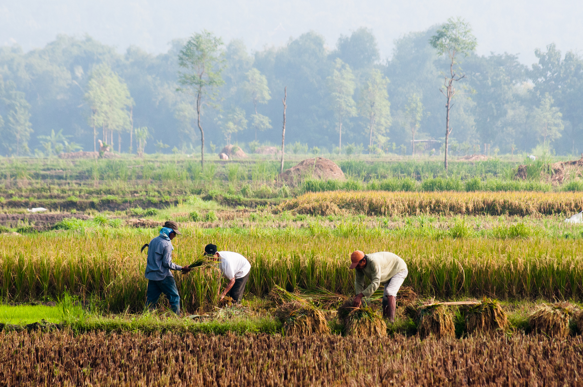
Farming in one of the large agricultural areas in Indonesia ©CIFOR I Flickr
Increased food demand from a growing world population is leading to an increased rate of investment in agriculture in regions with large stretches of fertile land. That these regions are largely rain-fed make them even more attractive for investors as they save the cost of expensive irrigation services. In fact, Hirsch argues that “the term land-grabbing is misleading. It should actually be water-grabbing as water is the foremost deciding factor—even more important than simply land abundance.”
Some researchers have found an interesting contrast between FDI in traditional sectors, such as manufacturing, and the ones in agricultural land. While investors in the former look for stable institutions and good governmental efficiency, FDI in land deals seems to target regions with less stable institutions. This positive relationship between corruption and FDI is completely counterintuitive. Hirsch says that one reason could be that “sometimes weaker institutions are easier to get through when it comes to such vast amount of lands. A lot of times these deals and contracts are oral and have no written proof—the contracts are not transparent anyway.”
For example in South Sudan, the land and soil conditions seem to be so good that investors aren’t deterred despite conflicts due to corrupt practices or inefficient government agencies.
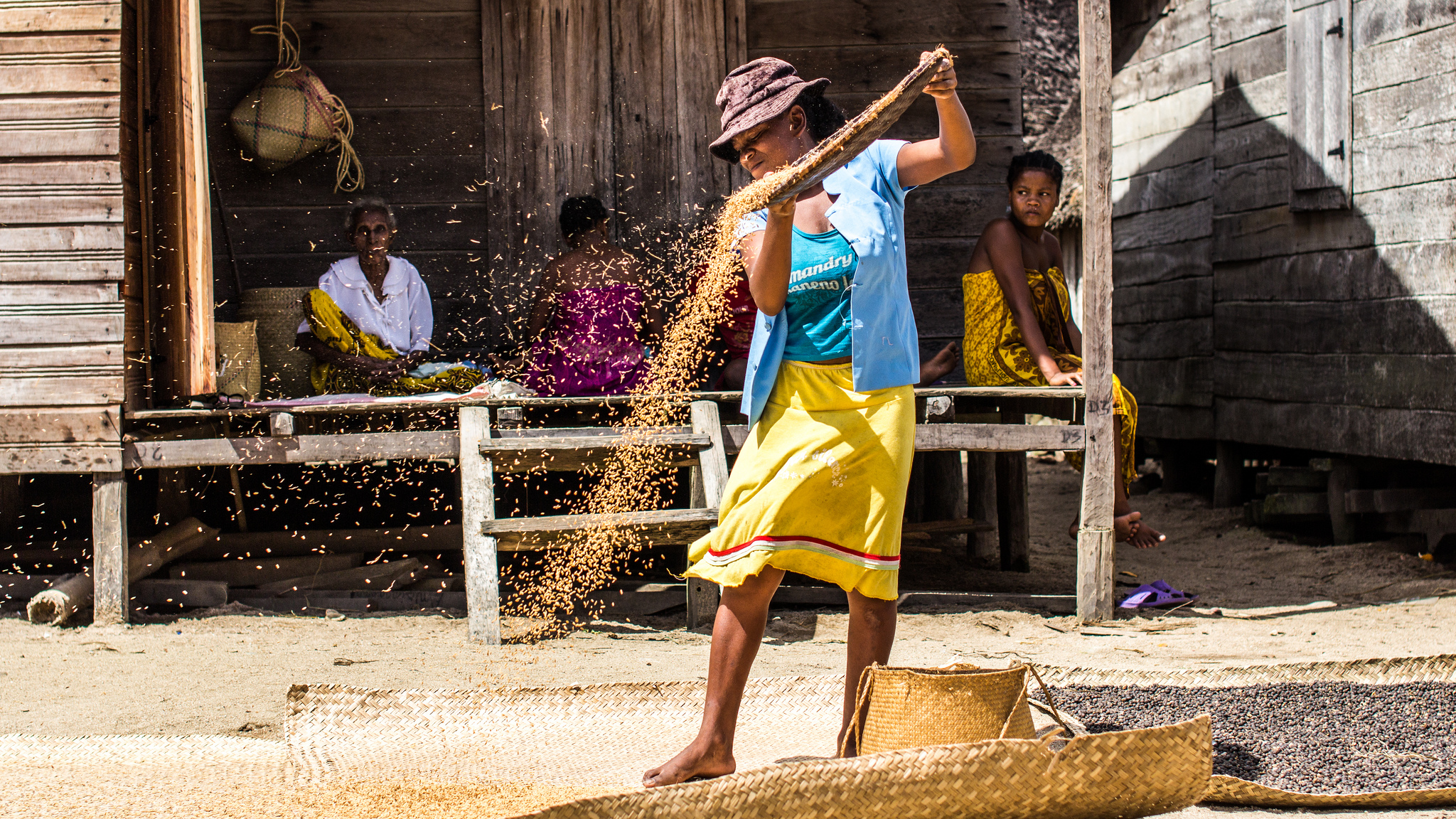
One of the indigenous communities in Madagascar, a place which is vulnerable to land acquisitions © IamNotUnique I Flickr
One area that often goes unnoticed is the violation of land rights of indigenous communities. If a government body decides to sell land or give out production licenses to investors for leasing the land without consulting the actual community, it is only much later that the affected community finds out that their land has been given away. Left with no land and hence no source of livelihood, these communities are forced to migrate to urban areas.
A strain of concern enters his voice as Hirsch talks about the impact. “Land as big as two times the area of Ecuador has been sold off in the past—but it accounts for a tiny percentage of the global production area.” With rising incomes and greater consumption of meat, a lot of land is used to produce animal feed crops. “This is a very inefficient way of using land,” he says.
During the summer program at IIASA, Hirsch is generating data that will help him look at these deals in detail and analyze the main factors that are taken into consideration before finalizing a land deal. At the moment he is only able to give an overview of land-grabbing at the global level. With more data on the location of the deals he can look at the factors that influence these decisions in the first place such as the proximity between the two countries involved in agricultural investments and the size of their economies.
While there is always huge media coverage when a scandal about these land acquisitions comes out in the open, Hirsch seems determined to dig deeper and uncover the dynamics involved.
About the researcher
Cornelius Hirsch is a research associate at the Austrian Institute of Economics and Research (WIFO). At IIASA he is working under the supervision of Tamas Krisztin and Linda See in the Ecosystems Services and Management Program (ESM).
This article gives the views of the author, and not the position of the Nexus blog, nor of the International Institute for Applied Systems Analysis.
May 17, 2016 | Citizen Science
By Dilek Fraisl, IIASA Ecosystems Services and Management Program
In October 2015, we launched our latest game, Picture Pile. The idea is simple: look at a pair of satellite images from different years and tell us if you can see any evidence of deforestation. Thanks to the participation of many volunteers, 2.69 million pictures have already been sorted in our pile of 5 million pairs. But we still have a long way to go, and we need your help to get us there!
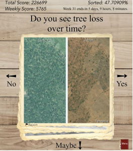
Screenshot from the game: click for more information (Image credit Tobias Sturn)
Deforestation is one of the most serious environmental problems in the world today. Forests cover a third of the land area on Earth, producing vital oxygen, habitats for a diversity of wildlife, and important ecosystem services. According to the World Wildlife Fund (WWF), some 46,000 to 58,000 square miles of forest are lost each year, which is equivalent to 48 football fields every minute. But this is a rough estimate since deforestation is very difficult to track. Reasons why are that satellite imagery can be of insufficient spatial resolution to map deforestation accurately, deforestation mostly occurs in small chunks that may not be visible from medium-resolution imagery, and very high-resolution data sets are expensive and can require big data processing capabilities, so can only be used for limited areas.
To help contribute to better mapping of deforestation, researchers in IIASA’s Earth Observation Systems (EOS) group, led by Steffen Fritz, have been working on novel projects to engage citizens in scientific data collection that can complement satellite-based traditional deforestation monitoring. One of the latest applications is Picture Pile, a game that makes use of very high-resolution satellite images spanning the last decade. Designed by Tobias Sturn, the aim is to provide data that can help researchers build a better map of deforestation. Players are provided with a pair of images that span two time periods and are then asked to answer a simple question: “Do you see tree loss over time?” After examining the image, the player drags the images to the right for “yes,” left for “no,” or down to indicate “maybe” when the deforestation is not clearly visible.
Every image is sorted multiple times by numerous independent players, in order to build confidence in the results, and also to gain an understanding of how good the players are at recognizing visible patterns of deforestation. Once enough data are collected at a single location, the images are taken out of the game and new ones are added, thereby increasing the spatial coverage of our mapped area over time. Right now we are focusing on Tanzania and Indonesia, two regions where we know there are problems with existing maps of deforestation.
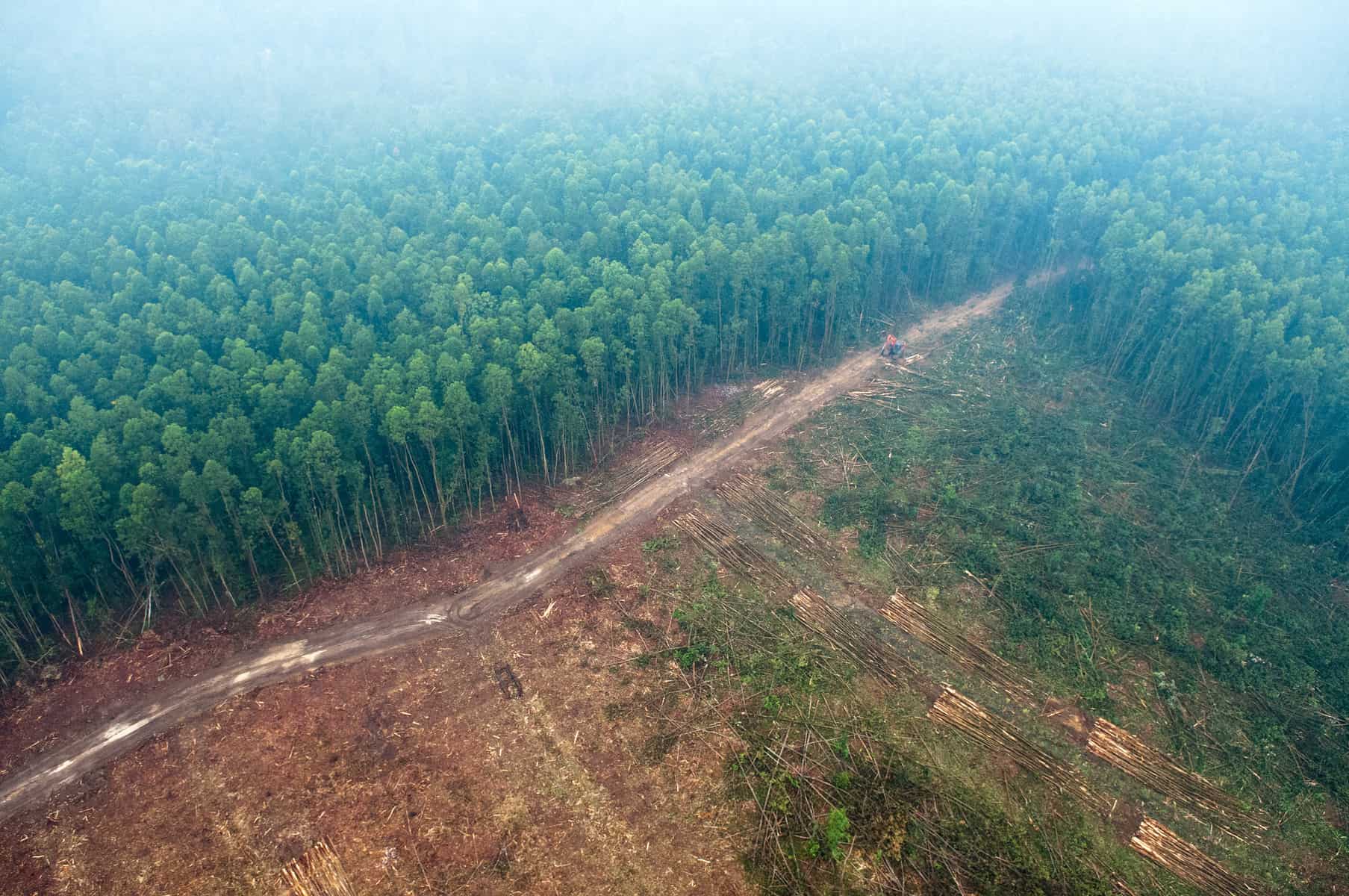
Picture Pile is focusing first on Indonesia (pictured) and Tanzania – two regions where there are problems with existing maps of deforestation. Photo (cc) Aulia Erlangga for Center for International Forestry Research (CIFOR).
Once the pile is fully sorted, the 5 million photos in the data set will be used to develop better maps of forest cover and forest loss using hybrid techniques developed by the group as well as inputs to classification algorithms. We will also use the data to validate the accuracy of existing global land cover maps. Finally, we will mine the data set to look for patterns regarding quality (for example, how many samples do we need to provide to the “crowd” before we can be confident enough to use their data in further research). In short, by integrating citizens in scientific research, Picture Pile will also help us improve the science of land cover monitoring through crowdsourcing mechanisms.
So please join in and help us get to the finish line. You can play Picture Pile in your browser or you can download the free iOS/Android app from the Apple and Google Play stores and play on your smartphone or tablet. Your contributions will help scientists like those at IIASA to tackle global problems such as deforestation and environmental degradation. At the same time you may win some great prizes: a brand new smartphone, a tablet, or a mini tablet.
More information:
Reference
Schepaschenko D, See L, Lesiv M, McCallum I, Fritz S, Salk C, Perger C, Schepaschenko M, Shvidenko A, Kovalevskyi S, Albrecht F, Kraxner F, Bun A, Maksyutov S, Sokolov A, Dürauer M, Obersteiner M. (2015) Global hybrid forest mask: synergy of remote sensing, crowd sourcing and statistics. Remote Sensing of the Environment, 162, 208-220. doi:10.1016/j.rse.2015.02.011
Note: This article gives the views of the author, and not the position of the Nexus blog, nor of the International Institute for Applied Systems Analysis.
Nov 2, 2015 | Environment
By Ping Yowargana, IIASA Ecosystems Services and Management Program
Recently, Indonesia has been combating its most severe forest fire of the decade. Around 43 million Indonesians have been exposed to hazardous fumes, and countless loss of biodiversity and ecosystem services has occurred. An estimated 1 billion tonnes of carbon emission has been released to the atmosphere. Within three months, Indonesia’s daily carbon emission has surpassed the average daily emissions of the whole US economy.

Firefighters outside Palangka Raya, Central Kalimantan, 15 October 2015.
Photo by Aulia Erlangga/ CIFOR
Forest fires in Indonesia are closely related to unsustainable agricultural practices spreading out throughout the country. Indonesia is the world’s largest producer of palm oil, with 8 million hectares of plantation area. Other than its significant contribution to the economy, and broadly debated effects on the environment, oil palm is also regarded as a promising solution to the country’s effort to achieve energy security. The current administration has set ambitious targets to increase national biofuel production, and to consume it domestically.
In this landscape of uncertainty and crisis, scientific support for Indonesian energy policy is more urgently needed than ever. That’s why it is one of our main focuses in the IIASA Tropical Forests Initiative (TFI).
“Scientific authority has to be the basis of our future energy policies,” said Mr. Sudirman Said, Indonesia’s Minister of Energy and Mineral Resources, at the opening session of our first collaborative screening workshop in September in Bandung, Java. In the workshop, jointly organized by IIASA and the ministry, we aimed at laying out a plan to establish a new decision support system for the ministry, based on IIASA’s energy systems models such as the renewable energy systems optimization model, BeWhere and the Model for Energy Supply Strategy Alternatives and their General Environmental Impact (MESSAGE).
Scientific decision support systems (DSS) are a tangible crystallization of bridging science to policy. A decision support system gathers information and analytical expertise in order to improve the quality of policy making, using feedback and evaluation from previous planning and policy implementation. As a practical approach in dealing with what scientists refer as complex adaptive systems, such DSS should be able to integrate visions of long-term planning with technical details that are important for daily executed policies.

The IIASA and the Ministry of Energy and Mineral Resources of Indonesia screening workshop took place from 15-17 September. ©MEMR
Indonesia’s energy sector is a typical example of a highly complex system. Currently, challenges of the sector are more cross-sectoral than ever. Issues that seem to have limited scopes, such as bioenergy, actually influence a broad swath of other areas including agriculture, land use change, air pollution, climate change and social equity.
For that reason, the approach we brought to the recent meeting relies on multiple models. BeWhere brings a snapshot perspective to explore energy supply options that best meet the objective set by policy makers, such as cost efficiency or least CO2 emissions, based on location specific energy demand, resource and infrastructure availability. On the other hand, MESSAGE brings a more macroscopic perspective, looking at various scenarios that project optimal solutions of meeting long-term energy demand in a certain region or country.
To have a truly systems perspective, the above approach cannot stand alone. Before we started looking at Indonesia’s energy sector, we had engaged local researchers in the tropics to localize IIASA’s Gobal Biosphere Management Model (GLOBIOM). GLOBIOM is used to analyze the competition for land use between agriculture, forestry, and bioenergy, which are the main land-based production sectors. Clearly, investigating further into the energy system will allow us to grasp a more holistic understanding and develop solutions to tackle challenges in tropical countries.
As one of IIASA’s pilot countries in the budding TFI, Indonesia represents conflicting realities of the tropics, which are essential to the planet’s well-being. Tropical forests help regulate the Earth’s climate system, while being home to huge biodiversity, millions of plant and animal species. However, the region is also highly challenged by domestic development needs and the growing consequences of a globalized economy. Abundant natural resources and land-intensive agricultural commodities, together with intensified infiltration of global supply chains and complicated socio-economic structures, have resulted in severe ecological pressures that are harmful to the region as well as the planet.
The TFI aspires to address such complexity by applying systems analysis together with regional policymakers. Such application implies a two-fold challenge. The first one is to put together IIASA’s various scientific tools to understand the broader picture that comes out from the integration of interrelated aspects of domestic development. Secondly, working together with policymakers leads to a mutual learning process. Policymakers learn to use scientific models and tools in their decision making process. In this process, fitting the models into the local context is an inevitable step that requires intense communication between scientist and practitioners. Eventually, this process will also benefit researchers by giving them a better understanding of the issue, and opening opportunities for further scientific investigation on new topics.
Note: This article gives the views of the author, and not the position of the Nexus blog, nor of the International Institute for Applied Systems Analysis.
-6.9174639107.6191228
Nov 3, 2014 | Environment
By Johannes Pirker and Aline Mosnier, IIASA Ecosystems Services and Management Research Program
In the late 2000s, Palm oil became a major target of environmental NGO’s working to save tropical forests. Bleak images of recently cleared forest sites left no doubt about the harmful impact of the commodity which today is omnipresent in our food—palm oil today is used in many everyday products such as chocolate bars, shampoo, and margarine. Campaigning against palm oil is a safe bet for NGO’s; it has become the North Korea among the vegetable oils.
The facts are clear: oil palm cultivation has expanded tremendously in recent years. Indonesia and Malaysia were and continue to be the epicenter of this expansion. In these two countries, new plantations have led to at least 3.7 million hectares of forest loss during the last 20 years, an area bigger than Belgium. This deforestation threatens not only animal and plant species, but expansion of palm oil plantations is increasingly occurring into carbon-rich peat soils, leading to the release of tremendous amounts of climate-warming CO2 into the atmosphere.

Palm oil mill of CDC in the South-West province in Cameroon, taken by Aline Soterroni, a 2010 IIASA YSSP participant and collaborator on the REDD-PAC project. Photo Credit: Aline Soterroni
On the other hand, even environmental NGOs cannot deny that the palm-oil boom has brought major benefits to the economies of producer countries. In Indonesia, the sector is estimated to employ on average 0.4 persons per hectare – at least 3.2 million jobs in a country where about 30 million people live in poverty. Unskilled slave labor? Well, no. Almost half of the plantations in the country are owned and managed by smallholders. In Thailand the share is as high as three quarters of the total plantation area.
Demand for palm oil remains high and there is now evidence that the palm oil boom might spill over to Central and Western Africa, where about 800,000 hectares of plantation concession have been granted to companies in recent years. Latin American countries too see the opportunity to benefit from the boom, such as Brazil, which has recently included oil palm in its reforestation plans, bolstered by a generous subsidy scheme for smallholders. So is the way inevitably paved for the palm oil industry to embark on a new round of forest-destroying plantation expansion?
Land use planning as a way forward
In many countries land is available – mainly degraded forests and grassland – to satisfy the future demand for palm oil in a less damaging way. Earmarking the right sites for palm plantations requires a good deal of capacity and knowledge by local authorities about where natural conditions are suitable for oil palm, which environmental and social safeguards need to be considered and at which place – a land use planning process.

The map above shows where palm oil production is possible on the globe when taking into account climate, soil, and topography features.
The first step toward more sustainable oil production is a map indicating where bio-physical conditions are suitable for oil palm cultivation. To that end, we constructed a global bio-physical suitability map, building on climate, soil and topography data at the resolution of 1 km. The map reveals that in fact the Amazon basin – the better part of it is located in Brazil – harbors by far the biggest stretch of suitable land, followed by the Democratic Republic of the Congo (DRC) and Indonesia.
IIASA supports the MOABI platform, a collaborative mapping initiative that aims to increase transparency and accountability on resource issues in DRC. Our oil palm suitability map will help to inform this process by providing insight to the sustainability of the expected expansion of oil palm in DRC in the coming years.

This map shows areas that are potentially suitable for oil palm cultivation in the Democratic Republic of the Congo. The map was developed from our data, and made interactive and zoomable by our partners the Moabi Project.
Biophysical suitability is not all
However, if and where plantations will start to appear will depend on many factors, most of which are economic :
- Availability, productivity and costs of land and labor
- The institutional set-up and support for the sector
- Accessibility to refinery plants and markets is a key determinant for oil palm plantations profitability
In order to address these issues, an economic model such as IIASA’s Global Biosphere Management Model (GLOBIOM) model can be deployed to gain insights in the likely development of the sector, help land use planning and explicitly show the trade-off between economic development and biodiversity protection.
Note: This article gives the views of the author, and not the position of the Nexus blog, nor of the International Institute for Applied Systems Analysis.
Mar 26, 2014 | Energy & Climate, Risk and resilience
By Reinhard Mechler, IIASA Risk, Policy, and Vulnerability Program
On March 25, member countries of the Intergovernmental Panel on Climate Change (IPCC) started discussing the key findings of the second volume of the Fifth Assessment Report (AR5) in Yokohama, Japan. The report focuses on climate-related impacts, risks and adaptation. Once approved by the 150+ governments present, together with IPCC’s other two parts of the report on physical climate science and mitigating greenhouse gases, it will constitute the scientific backbone for informing national and international climate policy over the coming years.

Flooded marketplace in Jakarta. Credit: Charles Wiriawan/Flickr (Creative Commons License)
A key aspect in climate adaptation is dealing with extreme events including natural disasters. It has become clear that extreme event risk constitutes a large part of the adaptation problem, particularly for developing countries and communities.
Despite this growing awareness, the international adaptation policy process is moving forward only slowly. Specifically, there is need for concrete advice for the Loss and Damage Mechanism, the main vehicle under the Climate Convention for dealing with climate-related impacts, which was agreed in Warsaw at the last Conference of the Parties in late 2013
In our commentary, published today in Nature Climate Change with colleagues from LSE, IVM and Deltares, we suggest that better understanding climate-related disaster risk and risk management can inform effective action on climate adaptation and point a way forward for policy and practice.
A key to moving forward is an actionable concept of risk. This involves identifying efficient and acceptable interventions based on recurrency of hazards—a concept known as risk layering. For example, for flood risk, this could mean identifying physical flood protection to deal with more frequent events, considering risk financing for infrequent disasters as well as relying on public and international compensation for extreme catastrophes. Risk layering overall points towards considering risk comprehensively as determined by climatic and non-climatic factors as well as considering portfolios of options that manage risks today and in the future.
The concept of risk layering underlies many areas of risk policy and management in agriculture, finance and insurance. It has been applied for disaster risks, mostly for insurance options, but not informed thinking on comprehensive risk management portfolios. Such broad understanding of risk management can also be helpful in identifying risks that are beyond adaptation–meriting international support, such as from the Green Climate Fund.
Climate risk management has now moved beyond theory. As one example, the megacity of Jakarta currently is setting up a multi-billion dollar program to manage increasing risk from sea level rise with large levees. This effort is integrated with a concern for managing flood risk and land subsidence, which are shaped by non-climatic factors, such as unplanned urbanization. The effort, therefore, involves options to implement acceptable building and zoning regulations for reducing exposure and vulnerability of houses and infrastructure to flooding.
Many policy-and implementation-specific questions remain. Over the coming months, IIASA researchers and our network will take the agenda on climate risk management forward with a focus on informing policy as well as providing actionable information on the ground.
Reference
Reinhard Mechler, Laurens M. Bouwer, Joanne Linnerooth-Bayer, Stefan Hochrainer-Stigler, Jeroen C. J. H. Aerts, Swenja Surminski & Keith Williges. 2014. Managing unnatural disaster risk from climate extremes. Nature Climate Change. March 26, 2014. http://www.nature.com/nclimate/journal/v4/n4/full/nclimate2137.html
Note: This article gives the views of the author, and not the position of the Nexus blog, nor of the International Institute for Applied Systems Analysis.
00


You must be logged in to post a comment.